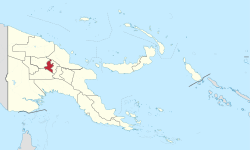
Western Highlands is a province of Papua New Guinea. The provincial capital is Mount Hagen. The province covers an area of 4,299 km2, and there are 362,850 inhabitants (2011 census), making the Western Highlands the most densely populated province (apart from the National Capital District). Tea and coffee are grown in the Western Highlands.
Western Highlands Province
Westen Hailans Provins (Tok Pisin) | |
|---|---|
 Western Highlands Province in Papua New Guinea | |
| Coordinates: 5°40′S 144°30′E / 5.667°S 144.500°E | |
| Country | Papua New Guinea |
| Capital | Mount Hagen |
| Districts | |
| Government | |
| • Governor | Paias Wingti 2012- |
| Area | |
• Total | 4,299 km2 (1,660 sq mi) |
| Population (2011 census) | |
• Total | 362,580 |
| • Density | 84/km2 (220/sq mi) |
| Time zone | UTC+10 (AEST) |
| HDI (2019) | 0.585[1] medium · 8th of 22 |
Split to create Jiwaka Province
editIn July 2009, Parliament passed legislation to create two new provinces by 2012. One of these was to be created by removing Jimi District, North Waghi District, and the South Waghi part of Anglimp-South Waghi District from the Western Highlands Province to form the new Jiwaka Province.[2] "Jiwaka" is a portmanteau combining the first two letters each of Jimi, Waghi and Kambia.
Jiwaka Province officially came into being on 17 May 2012.[3]
Economy
editThe Western Highlands economy is primarily based on coffee. Coffee is grown on plantations and small-holder blocks. They are picked, dried and processed for export. In addition, tea is also a major crop grown and processed, but in plantations by W. R. Carpenter & Co Ltd for local consumption and export. Apart from these, vegetables are grown for the domestic market, and sold mainly to markets Lae and Port Moresby. [clarification needed]
Districts and LLGs
editSince the separation of Jiwaka there are now four districts in the province. Each district has one or more Local Level Government (LLG) areas. For census purposes, the LLG areas are subdivided into wards and those into census units.[4][5][6]
| District | District Capital | LLG Name |
|---|---|---|
| Dei District | Dei | Dei Rural (Muglamp) |
| Kotna Rural | ||
| Mount Hagen District | Mount Hagen | Mount Hagen Rural |
| Mount Hagen Urban | ||
| Mul-Baiyer District | Baiyer | Baiyer Rural |
| Lumusa Rural | ||
| Mul Rural | ||
| Tambul-Nebilyer District | Tambul | Mount Giluwe Rural |
| Nebilyer Rural |
Provincial leaders
editThe province was governed by a decentralised provincial administration, headed by a Premier, from 1978 to 1995. Following reforms taking effect that year, the national government reassumed some powers, and the role of Premier was replaced by a position of Governor, to be held by the winner of the province-wide seat in the National Parliament of Papua New Guinea.[7][8]
Premiers (1978–1995)
edit| Premier | Term |
|---|---|
| Nambuga Mara | 1978–1984 |
| Kagul Koroka | 1984 |
| Philip Kapal | 1984–1987 |
| provincial government suspended | 1987 |
| Philip Kapal | 1987–1990 |
| Lukas Roika | 1990–1992 |
| provincial government suspended | 1992–1995 |
Governors (1995–present)
edit| Governor | Term |
|---|---|
| Paias Wingti | 1995–1997 |
| Robert Lak | 1997–2002 |
| Paias Wingti | 2002–2007 |
| Tom Olga | 2007–2012 |
| Paias Wingti | 2017–2022 |
| Wai Rapa | Since 2022 |
Members of the National Parliament
editThe province and each district is represented by a Member of the National Parliament. There is one provincial electorate and each district is an open electorate.
| Electorate | Member |
|---|---|
| Western Provincial | Zuriel Voivoi |
| Baiyer-Mul Open | Jacob Maki |
| Dei Open | Steven Pim |
| Hagen Open | William Duma |
| Tambul-Nebilyer Open | Win Bakri Daki |
References
edit- ^ "Sub-national HDI - Area Database - Global Data Lab". hdi.globaldatalab.org. Archived from the original on 2018-09-23. Retrieved 2020-04-18.
- ^ "PNG to create two new provinces" Archived 2014-10-24 at the Wayback Machine, Sydney Morning Herald, July 15, 2009
- ^ "PNG’S new province Hela, Jiwaka declared" Archived 2012-07-24 at the Wayback Machine, The National, 17 May 2012
- ^ National Statistical Office of Papua New Guinea
- ^ "Census Figures by Wards - Highlands Region". www.nso.gov.pg. 2011 National Population and Housing Census: Ward Population Profile. Port Moresby: National Statistical Office, Papua New Guinea. 2014. Archived from the original on 2019-05-18. Retrieved 2019-06-04.
- ^ "Final Figures". www.nso.gov.pg. 2011 National Population and Housing Census: Ward Population Profile. Port Moresby: National Statistical Office, Papua New Guinea. 2014. Archived from the original on 2015-09-06. Retrieved 2019-06-04.
- ^ May, R. J. "8. Decentralisation: Two Steps Forward, One Step Back". State and society in Papua New Guinea: the first twenty-five years. Australian National University. Archived from the original on 1 April 2019. Retrieved 31 March 2017.
- ^ "Provinces". rulers.org. Archived from the original on 28 July 2018. Retrieved 31 March 2017.
