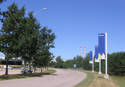
Waterville is a Canadian community in Kings County, Nova Scotia. It is administratively part of the village of Cornwallis Square.
Waterville, Kings County | |
|---|---|
Village | |
 Michelin plant in Waterville, Nova Scotia | |
Location of Waterville in Nova Scotia | |
| Coordinates: 45°3′N 64°40′W / 45.050°N 64.667°W | |
| Country | |
| Province | |
| County | Kings |
| Elevation | 28 m (92 ft) |
Located on the Cornwallis River, the community is located 15 kilometres west of Kentville and is home to a Michelin tire factory, as well as the Nova Scotia Youth Centre.
As of 2021, the population was 703.
Climate
edit| Climate data for Waterville | |||||||||||||
|---|---|---|---|---|---|---|---|---|---|---|---|---|---|
| Month | Jan | Feb | Mar | Apr | May | Jun | Jul | Aug | Sep | Oct | Nov | Dec | Year |
| Record high °C (°F) | 18 (64) |
17.5 (63.5) |
24.5 (76.1) |
27.5 (81.5) |
33.5 (92.3) |
34 (93) |
34.5 (94.1) |
36 (97) |
33.5 (92.3) |
27 (81) |
23 (73) |
18.5 (65.3) |
36 (97) |
| Mean daily maximum °C (°F) | −1.2 (29.8) |
−0.2 (31.6) |
3.7 (38.7) |
9.9 (49.8) |
17.0 (62.6) |
22.2 (72.0) |
25.6 (78.1) |
25.1 (77.2) |
20.5 (68.9) |
13.9 (57.0) |
7.8 (46.0) |
2 (36) |
12.2 (54.0) |
| Mean daily minimum °C (°F) | −10.1 (13.8) |
−9.5 (14.9) |
−5.4 (22.3) |
0.3 (32.5) |
5.3 (41.5) |
10.1 (50.2) |
13.6 (56.5) |
13.1 (55.6) |
9.2 (48.6) |
4.1 (39.4) |
0.1 (32.2) |
−5.9 (21.4) |
2.1 (35.8) |
| Record low °C (°F) | −31 (−24) |
−35.5 (−31.9) |
−26 (−15) |
−14.5 (5.9) |
−5.5 (22.1) |
−0.5 (31.1) |
3.5 (38.3) |
1 (34) |
−4 (25) |
−8 (18) |
−17 (1) |
−26.5 (−15.7) |
−35.5 (−31.9) |
| Average precipitation mm (inches) | 111.7 (4.40) |
86.6 (3.41) |
103.8 (4.09) |
92.7 (3.65) |
98 (3.9) |
76.6 (3.02) |
77.6 (3.06) |
75.2 (2.96) |
102 (4.0) |
109.3 (4.30) |
119.1 (4.69) |
114.2 (4.50) |
1,166 (45.9) |
| Source: Environment Canada[1] | |||||||||||||
Demographics
editIn the 2021 Census of Population conducted by Statistics Canada, Waterville had a population of 703 living in 314 of its 327 total private dwellings, a change of -5.9% from its 2016 population of 747. With a land area of 1.79 km2 (0.69 sq mi), it had a population density of 392.7/km2 (1,017.2/sq mi) in 2021.[2]
References
edit- ^ Environment Canada Canadian Climate Normals 1981–2010, accessed 15 January 2018
- ^ "Population and dwelling counts: Canada and designated places". Statistics Canada. 9 February 2022. Retrieved 9 May 2022.
45°3′10.26″N 64°40′28.15″W / 45.0528500°N 64.6744861°W

