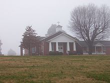
Trinity United Methodist Church (Nutbush, Tennessee)
Trinity United Methodist Church is a church in Nutbush, Haywood County, Tennessee was founded in 1822. Planters allowed their slaves to attend church with them.
| Trinity United Methodist Church | |
|---|---|
 Trinity United Methodist Church in Nutbush (2007) | |
 | |
| Country | United States |
| Denomination | United Methodist |
| History | |
| Founded | 1822 |
The church is located south of Tennessee State Route 19. Part of the roadway was named "Tina Turner Highway" in 2002 in honor of popular singer Tina Turner, who lived as a child in Nutbush.[1][2][3]
Trinity Cemetery
edit| Trinity Cemetery | |
|---|---|
| Trinity Cemetery (2007) | |
More than 50 Civil War soldiers, from both Confederate and Union sides, are buried in the Trinity Cemetery associated with the Trinity United Methodist Church. The Trinity Cemetery is noted as one of the best-kept cemeteries in the county.[4]
Old State Route 19
editTrinity United Methodist Church is located just south of Nutbush, close to a section of Old Tennessee State Route 19.
In 2002 a stretch of State Route 19 between Brownsville and Nutbush was named "Tina Turner Highway" after singer Tina Turner, who grew up in Nutbush.[1][2][3]
See also
editReferences
edit- ^ a b Wilder, John S. (January 17, 2002). "SB 2798: Highway Signs - "Tina Turner Highway"" (PDF). Legislation Archives - Bills and Resolutions: 102nd General Assembly. Nashville, TN: Tennessee Senate. Retrieved June 26, 2010.
- ^ a b Fitzhugh, Craig (January 22, 2002). "HB 2535: Highway Signs - "Tina Turner Highway"" (PDF). Legislation Archives - Bills and Resolutions: 102nd General Assembly. Nashville, TN: Tennessee House of Representatives. Retrieved June 26, 2010.
- ^ a b Associated Press (September 25, 2002). "Highway to Be Named for Tina Turner". AP Online News Wire. Archived from the original on November 4, 2012. Retrieved June 26, 2010.
- ^ Haywood County, TN Genealogy, Rootsweb
Further reading
edit- Norris, Sharon (2000). Black America Series: Haywood County Tennessee. Mount Pleasant, SC: Arcadia Publishing. ISBN 0-7385-0605-2.
35°41′22″N 89°24′29″W / 35.689369°N 89.408068°W