Sanzhi District (Chinese: 三芝區; pinyin: Sānzhī Qū) is a rural district in northern New Taipei, Taiwan. It is notable as the hometown of the former president Lee Teng-hui.
Sanzhi
三芝區 Sanchih, Sanjhih, Sanshi | |
|---|---|
| Sanzhi District | |
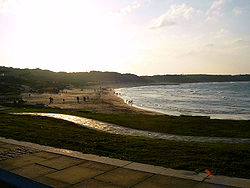
 Beach in Sanzhi | |
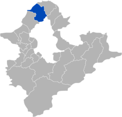
 Sanzhi District in New Taipei City | |
| Coordinates: 25°14′12″N 121°31′31″E / 25.23667°N 121.52528°E | |
| Country | Republic of China (Taiwan) |
| Region | Northern Taiwan |
| Special municipality | New Taipei City |
| Area | |
• Total | 65.9968 km2 (25.4815 sq mi) |
| Population (February 2023) | |
• Total | 22,190 |
| Time zone | UTC+8 (CST) |
| Postal code | 252 |
| Area code | 02 |
| Website | www |
| Sanzhi District | |||||||||||||||||||
|---|---|---|---|---|---|---|---|---|---|---|---|---|---|---|---|---|---|---|---|
| Chinese | 三芝區 | ||||||||||||||||||
| |||||||||||||||||||
History
editDuring the period of Japanese rule, Sanshi Village (三芝庄), and was governed under Tamsui District (淡水郡) of Taihoku Prefecture.
Administrative divisions
editEducation
editTourist attractions
editTransportation
editThe main road route through Sanzhi is the Provincial Highway No. 2. There are also a number of county-level highways within the district.
Notable natives
edit- Chiang Wen-yeh, musician and composer active mainly in Japan and the People's Republic of China[5]
- Lee Teng-hui, former ROC president, spiritual leader of the Taiwan Solidarity Union
- Lu Hsiu-yi, former Democratic Progressive Party politician and member of the Legislative Yuan
- Tseng Wen-hui, former First Lady of the Republic of China, wife of former President Lee Teng-hui
- Tu Tsung-ming, founder of Kaohsiung Medical University and the first Taiwanese PhD
Climate
edit| Climate data for Sanzhi District (2010–2023 normals, extremes 2010–present) | |||||||||||||
|---|---|---|---|---|---|---|---|---|---|---|---|---|---|
| Month | Jan | Feb | Mar | Apr | May | Jun | Jul | Aug | Sep | Oct | Nov | Dec | Year |
| Record high °C (°F) | 27.1 (80.8) |
28.2 (82.8) |
31.5 (88.7) |
31.9 (89.4) |
34.9 (94.8) |
35.0 (95.0) |
40.3 (104.5) |
38.5 (101.3) |
37.4 (99.3) |
35.7 (96.3) |
31.7 (89.1) |
29.1 (84.4) |
40.3 (104.5) |
| Mean daily maximum °C (°F) | 18.1 (64.6) |
18.7 (65.7) |
21.0 (69.8) |
24.3 (75.7) |
27.7 (81.9) |
30.7 (87.3) |
32.8 (91.0) |
32.5 (90.5) |
30.6 (87.1) |
26.5 (79.7) |
23.7 (74.7) |
19.3 (66.7) |
25.5 (77.9) |
| Daily mean °C (°F) | 15.7 (60.3) |
15.8 (60.4) |
17.9 (64.2) |
21.2 (70.2) |
24.8 (76.6) |
27.7 (81.9) |
29.5 (85.1) |
29.2 (84.6) |
27.7 (81.9) |
23.9 (75.0) |
21.3 (70.3) |
17.0 (62.6) |
22.6 (72.8) |
| Mean daily minimum °C (°F) | 13.7 (56.7) |
13.6 (56.5) |
15.3 (59.5) |
18.5 (65.3) |
22.3 (72.1) |
25.2 (77.4) |
26.7 (80.1) |
26.5 (79.7) |
25.1 (77.2) |
22.4 (72.3) |
19.4 (66.9) |
15.1 (59.2) |
20.3 (68.6) |
| Record low °C (°F) | 3.4 (38.1) |
6.4 (43.5) |
6.9 (44.4) |
11.4 (52.5) |
14.1 (57.4) |
18.7 (65.7) |
23.6 (74.5) |
23.1 (73.6) |
20.4 (68.7) |
16.8 (62.2) |
11.7 (53.1) |
5.9 (42.6) |
3.4 (38.1) |
| Average precipitation mm (inches) | 315.4 (12.42) |
308.7 (12.15) |
213.3 (8.40) |
169.8 (6.69) |
342.9 (13.50) |
271.3 (10.68) |
87.5 (3.44) |
172.0 (6.77) |
190.5 (7.50) |
288.8 (11.37) |
306.9 (12.08) |
458.8 (18.06) |
3,125.9 (123.06) |
| Average precipitation days | 17.7 | 17.3 | 15.7 | 13.4 | 14.0 | 11.7 | 6.3 | 9.7 | 10.9 | 14.6 | 17.0 | 18.0 | 166.3 |
| Average relative humidity (%) | 81.5 | 85.1 | 82.1 | 80.8 | 82.5 | 81.3 | 76.2 | 77.5 | 78.2 | 78.3 | 82.5 | 80.9 | 80.6 |
| Source 1: Central Weather Administration[6] | |||||||||||||
| Source 2: Atmospheric Science Research and Application Databank (precipitation 2010–2023, precipitation days and humidity 2009–2024)[7] | |||||||||||||
See also
editReferences
edit- ^ 行政區域. Sanzhi District Office New Taipei City 新北市三芝區公所 (in Chinese (Taiwan)). 24 April 2018. Retrieved 6 July 2019.
新庄里 古庄里 埔頭里 橫山里 茂長里 後厝里 埔坪里 錫板里 八賢里 福德里 圓山里 店子里 興華里
- ^ "2018 Local Elections". Central Election Commission. Retrieved 6 July 2019.
Baxian Vil. Putou Vil. Guzhuang Vil. Xinzhuang Vil. Puping Vil. Maozhang[sic] Vil. Hengshan Vil. Xiban Vil. Houcuo Vil. Fude Vil. Yuanshan Vil. Dianzi Vil. Xinghua Vil.
, Chinese version: [1] - ^ 1060713 茂長里門面綠美化 馬賽克磚牆打造藝術村. Archived from the original on 2021-12-20. Every time '茂長' is spoken aloud in this video, it seems to be read as 'Màocháng'.
- ^ Maochang Cun (Approved - N) at GEOnet Names Server, United States National Geospatial-Intelligence Agency
- ^ "江文也 (Jiang Wen-ye)" (in Chinese). Sanzhi District Government.
- ^ "月報表(逐日資料) : 三芝 (撤銷站) (C0AD00)". Central Weather Administration. Retrieved 8 October 2024.
- ^ "中央氣象署 測站氣候資料 : 新北三芝 C0AD00". Atmospheric Science Research and Application Databank. Retrieved 8 October 2024.
External links
editWikimedia Commons has media related to Sanzhi District, New Taipei.
Wikivoyage has a travel guide for Sanzhi.