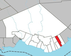
Saint-Godefroi (formerly spelled as Saint-Godefroy) is a township municipality in the Canadian province of Quebec, located within the Bonaventure Regional County Municipality. The township had a population of 350 in the 2021 Canadian census.
Saint-Godefroi | |
|---|---|
 Harbour at Saint-Godefroi | |
 Location within Bonaventure RCM | |
| Coordinates: 48°05′N 65°07′W / 48.083°N 65.117°W[1] | |
| Country | Canada |
| Province | Quebec |
| Region | Gaspésie– Îles-de-la-Madeleine |
| RCM | Bonaventure |
| Constituted | December 16, 1913 |
| Government | |
| • Mayor | Gérard Litalien |
| • Federal riding | Gaspésie— Îles-de-la-Madeleine |
| • Prov. riding | Bonaventure |
| Area | |
| • Total | 64.07 km2 (24.74 sq mi) |
| • Land | 63.57 km2 (24.54 sq mi) |
| Population (2021)[3] | |
| • Total | 350 |
| • Density | 5.5/km2 (14/sq mi) |
| • Pop (2016-21) | |
| • Dwellings | 200 |
| Time zone | UTC−5 (EST) |
| • Summer (DST) | UTC−4 (EDT) |
| Postal code(s) | |
| Area code(s) | 418 and 581 |
| Highways | |
| Website | www |
It is situated on the north shore of Chaleur Bay along Quebec Route 132. In addition to Saint-Godefroi itself, the township also includes the community of Kelly (48°6′53″N 65°8′7″W / 48.11472°N 65.13528°W).[4]
History
editSettlement began in the mid-19th century, and in 1873 the Parish of Saint-Godefroi was founded, named in honour of Charles-Godefroi Fournier (1829-1902), priest and founder of the parish. In 1889, its post office opened under the name of Saint-Godfroy.[1]
On December 16, 1913, the Township Municipality of Saint-Godefroy was created when the Township Municipality of Hope was divided in two. In 1924, Saint-Godefroy lost more than half its area when the Municipality of Shigawake was formed.[5] In 1940, the spelling of the post office name was adjusted to Saint-Godefroi, while the township's name was not corrected until much later (the 1981 census was the last census to use the spelling "Saint-Godefroy*).[1]
Demographics
editIn the 2021 Census of Population conducted by Statistics Canada, Saint-Godefroi had a population of 350 living in 177 of its 200 total private dwellings, a change of -7.9% from its 2016 population of 380. With a land area of 63.57 km2 (24.54 sq mi), it had a population density of 5.5/km2 (14.3/sq mi) in 2021.[3]
| 2021 | 2016 | 2011 | |
|---|---|---|---|
| Population | 350 (-7.9% from 2016) | 380 (-6.2% from 2011) | 405 (+9.5% from 2006) |
| Land area | 63.57 km2 (24.54 sq mi) | 63.52 km2 (24.53 sq mi) | 64.41 km2 (24.87 sq mi) |
| Population density | 5.5/km2 (14/sq mi) | 6.0/km2 (16/sq mi) | 6.3/km2 (16/sq mi) |
| Median age | 59.6 (M: 60.4, F: 58.0) | 56.0 (M: 54.7, F: 57.6) | 54.6 (M: 53.4, F: 55.3) |
| Private dwellings | 200 (total) 177 (occupied) | 214 (total) 180 (occupied) | 217 (total) |
| Median household income | $54,800 | $46,848 | $.N/A |
|
|
| |||||||||||||||||||||||||||||||||||||||||||||||||||||||||||||||
| Population counts are not adjusted for boundary changes. Source: Statistics Canada[11] | |||||||||||||||||||||||||||||||||||||||||||||||||||||||||||||||||
Mother tongue (2021):[3]
- English as first language: 10.0%
- French as first language: 87.1%
- English and French as first language: 1.4%
- Other as first language: 1.4%
Local government
editList of former mayors:
- Réginald Joseph (...–2005)
- Gérard-Raymond Blais (2005–2017)
- Grenade Grenier (2017–2022)
- Gérard Litalien (2022–present)
See also
editReferences
edit- ^ a b c "Banque de noms de lieux du Québec: Reference number 56676". toponymie.gouv.qc.ca (in French). Commission de toponymie du Québec.
- ^ a b "Répertoire des municipalités: Geographic code 05015". www.mamh.gouv.qc.ca (in French). Ministère des Affaires municipales et de l'Habitation. Retrieved 2024-09-24.
- ^ a b c d "Saint-Godefroi (Code 2405015) Census Profile". 2021 census. Government of Canada - Statistics Canada. Retrieved 2024-09-24.
- ^ "Kelly". Geographical Names Data Base. Natural Resources Canada. Retrieved 24 September 2024.
- ^ "Banque de noms de lieux du Québec: Shigawake". toponymie.gouv.qc.ca (in French). Commission de toponymie du Québec. Retrieved 2024-09-24.
- ^ "2021 Community Profiles". 2021 Canadian census. Statistics Canada. February 4, 2022. Retrieved 2022-04-27.
- ^ "2016 Community Profiles". 2016 Canadian census. Statistics Canada. August 12, 2021. Retrieved 2024-09-24.
- ^ "2011 Community Profiles". 2011 Canadian census. Statistics Canada. March 21, 2019. Retrieved 2014-02-01.
- ^ "2006 Community Profiles". 2006 Canadian census. Statistics Canada. August 20, 2019.
- ^ "2001 Community Profiles". 2001 Canadian census. Statistics Canada. July 18, 2021.
- ^ 1996, 2001, 2006, 2011, 2016 census
