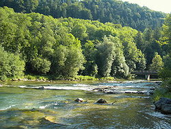
The Mangfall is a river of Upper Bavaria, Germany. It is a left tributary of the Inn. The Mangfall is the outflow of the Tegernsee lake and discharges into the Inn in Rosenheim. The Mangfall is 63 km (39 mi) long.
| Mangfall | |
|---|---|
 Mangfall bend, looking downstream | |
 | |
| Location | |
| Country | Germany |
| State | Bavaria |
| Reference no. | DE: 182 |
| Physical characteristics | |
| Source | |
| • location | Sources: tailstream of the Tegernsee |
| • coordinates | 47°44′52″N 11°44′07″E / 47.74778°N 11.73528°E |
| • elevation | 726 m above sea level (NN) |
| Mouth | |
• location | in Rosenheim into the Inn |
• coordinates | 47°51′35″N 12°08′10″E / 47.85972°N 12.13611°E |
• elevation | 444 m above sea level (NN) |
| Length | 62.9 km (39.1 mi) [1] |
| Basin size | 1,098 km2 (424 sq mi) [1] |
| Basin features | |
| Progression | Inn→ Danube→ Black Sea |
| Landmarks |
|
| Tributaries | |
| • left | Festenbach (also called Moosbach), Steinbach, Glonn |
| • right | Schwärzenbach, Schlierach, Moosbach, Leitzach, Hainerbach, Goldbach (auch Mühlbach), Kaltenbrunnbach, Kalten |
| Waterbodies | Lakes: Tegernsee |

Towns and villages on the Mangfall
edit- Gmund am Tegernsee
- Valley
- Weyarn
- Grub (district of Valley)
- Feldkirchen-Westerham
- Feldolling
- Bruckmühl
- Götting (district of Bruckmühl)
- Heufeld (district of Bruckmühl)
- Bad Aibling
- Kolbermoor
- Rosenheim
See also
editReferences
edit- ^ a b Complete table of the Bavarian Waterbody Register by the Bavarian State Office for the Environment (xls, 10.3 MB)
External links
editWikimedia Commons has media related to Mangfall.