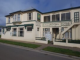
Ringarooma is a small town in north-eastern Tasmania. It is located just east of the Ringarooma River and is about 12 km (7.5 mi) south-west from Derby and 55 km (34 mi) east-northeast from Launceston. The area around Ringarooma is known for dairy farming and timber harvesting. The locality is in the Dorset Council local government area, except for about 2.5% which is in the Break O'Day Council area.
| Ringarooma Tasmania | |
|---|---|
 Area surrounding Ringarooma which is right of centre | |
| Coordinates | 41°14′S 147°40′E / 41.233°S 147.667°E |
| Population | 338 (2016 census)[1] |
| Established | 1882 |
| Postcode(s) | 7263 |
| Elevation | 283 m (928 ft) |
| Location |
|
| LGA(s) | Dorset Council |
| State electorate(s) | Bass |
| Federal division(s) | Bass |
History
editThe district was opened up to farming in the 1860s, and the town itself was founded in 1882 when a rural property was subdivided into lots by landowner Christopher Krushka. It was initially known as Krushka Town before being renamed Ringarooma in November 1888, taking on the name of a coastal town near Bridport, which was renamed Boobyalla.[2][3] Ringarooma is believed to be an Aboriginal word meaning happy hunting ground.[4]
Ringarooma Post Office opened on 1 October 1874.[5]
In 2017 it was named the Legendary Capital of Tasmania.[6]
Present day
editToday, Ringarooma is a small town surrounded by dairy farming and timber harvesting country[4] near mountains such as Mount Victoria and Ben Lomond.
The Mount Victoria Forest Reserve that contains Ralphs Falls[7] and Cash Gorge/Falls[8] is about 15 km (9.3 mi) to the SouthEast of Ringarooma, while the St Columba Falls is a further 10 km (6.2 mi) away (70 km [43 mi] by road).[9][10]
Notable people
edit- Bartlett Adamson, journalist, poet, author and political activist was born here.[11]
- Alfred Gaby, recipient of the Victoria Cross was born at Springfield near here.[12]
- Alan Lindsay Wardlaw, pastoralist, soldier and parliamentarian, managed a farm nearby.
- Samuel Hawkes was the first Member of the Tasmanian House of Assembly for Ringarooma.
References
edit- ^ Australian Bureau of Statistics (27 June 2017). "Ringarooma (L) (Urban Centre/Locality)". 2016 Census QuickStats. Retrieved 23 July 2017.
- ^ Beswick, Dorothy (1988). As The River Flows, Mount Victoria to Boobyalla. Ringarooma Council. ISBN 0-7316-1966-8.
- ^ "NS2809 – The E R Pretyman Index: NS2809-1–16(Ria – San)". stors.tas.gov.au. Libraries Tasmania. p. 20. Retrieved 26 September 2018.
- ^ a b Alison Andrews (11 March 2009). "Ringarooma: A'happy hunting ground'". The Examiner. Retrieved 26 September 2018.
- ^ Premier Postal History. "Post Office List". Premier Postal Auctions. Retrieved 16 June 2012.
- ^ "Industry News: Ringarooma: little town, big heart". The Australian Dairyfarmer. Fairfax Agricultural Media. 24 July 2017. Retrieved 26 September 2018.
- ^ "Ralphs Falls". parks.tas.gov.au. Parks & Wildlife Service Tasmania. Retrieved 30 September 2018.
- ^ "Ringarooma, Ralph Falls & Cash's Gorge". northeasttasmania.com.au. North East Tasmania Tourism. Retrieved 30 September 2018.
- ^ "St. Columba Falls". parks.tas.gov.au. Parks & Wildlife Service Tasmania. Retrieved 30 September 2018.
- ^ "Ringarooma, Tasmania 7263 Saint Columba Falls State Reserve, Pyengana Tas 7216". google.com. Retrieved 30 September 2018.
- ^ Robert Darby. "Adamson, George Ernest Bartlett (1884–1951)". adb.anu.edu.au. National Centre of Biography. Retrieved 26 September 2018.
- ^ D. Elliot. "Gaby, Alfred Edward (1892–1918)". adb.anu.edu.au. National Centre of Biography. Retrieved 26 September 2018.
