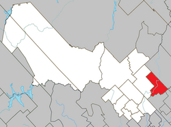
Notre-Dame-de-Montauban (French pronunciation: [nɔtʁə dam də mɔ̃tobɑ̃]) is a municipality in the Mauricie region in Quebec, Canada. The municipality is on the northern edge of Mékinac Regional County Municipality and the administrative region of Mauricie and includes the population centres of Notre-Dame-des-Anges and Montauban-les-Mines. Both communities are located along route 367 and are about 7 kilometres (4.3 mi) apart.
Notre-Dame-de-Montauban | |
|---|---|
 | |
 Location within Mékinac RCM | |
| Coordinates: 46°52′N 72°20′W / 46.867°N 72.333°W[1] | |
| Country | |
| Province | |
| Region | Mauricie |
| RCM | Mékinac |
| Constituted | January 3, 1976 |
| Government | |
| • Mayor | Nathalie Groleau |
| • Federal riding | Saint-Maurice—Champlain |
| • Prov. riding | Laviolette |
| Area | |
• Total | 173.70 km2 (67.07 sq mi) |
| • Land | 162.40 km2 (62.70 sq mi) |
| Population | |
• Total | 815 |
| • Density | 5/km2 (10/sq mi) |
| • Pop 2016-2021 | |
| • Dwellings | 731 |
| Time zone | UTC−5 (EST) |
| • Summer (DST) | UTC−4 (EDT) |
| Postal code(s) | |
| Area code(s) | 418 and 581 |
| Highways | |
| Website | www |
Tourist activities and the resort are significant industries today. The marked trails for recreational vehicles (snowmobile, ATV, etc.), the hunting, fishing and forest walks attract many visitors. Nine out of the fall of the Batiscan River is the major tourist attraction. On the west bank, the municipality has built a beautiful park with a gateway to reach a large rock in the middle of the fall.
At Notre-Dame-de-Montauban, the population is approximately 850, with a median age of 45 years. The most significant age group is 25-44. In summer season, the population doubles because of country cottages. The town has two Catholic places of worship, the church of Notre-Dame-des-Anges (Our Lady of the Angels) and the chapel of Montauban.
Geography
editThe municipality covers 163.53 square kilometres (63.14 sq mi) and has 53 lakes.[4] Batiscan river, flowing from north to south, divides the city in two. The village of Notre-Dame-des-Anges is located on the east side of the river, downstream from the breathtaking falls. The village of Montauban-les-Mines is located in the east, near the limit of Saint-Ubalde, Quebec. The village of Notre-Dame-de-Montauban is part of the Batiscanie, Quebec, being in the watershed Batiscan River. However, an area at the southeast of the municipal territory, at the limit of Saint-Ubalde, Quebec, is rather dependent on the watershed Sainte-Anne River.
Economy
editThe railway from Hervey-Jonction to Chambord (Lac Saint-Jean) has contributed greatly to the economic growth of the Notre-Dame-des-Anges sector. The railway station was built on the west side of the Batiscan River.
Historically, the local economy was mainly based on agriculture and forestry. The agricultural zone occupies about 8% of the municipal territory in the area; nearly 44% is cultivated and 51% is in oak. Some pastures are also intended for breeding cattle.[5] While the Montauban-les-Mines area experienced an economic boom in the mining industry, since the beginning of the 20th century.
In the history of Notre-Dame-de-Montauban, 34 sawmills have been identified. "Scierie Montauban" (Montauban sawmill) is be the major business in the area and the only sawmill to survive. Other local SMEs operating specialize in construction, mechanical equipment and cabinetry.
Municipal timeline
edit- 1882: Constitution of the "municipality of Notre-Dame-des-Anges-de-Montauban" from the unorganized Portneuf territories.
- 24: The "municipality of the parish of Saint-Rémi" stands "Notre-Dame-des-Anges-de-Montauban".
- 1919: The "municipality of Notre-Dame-des-Anges" stands "Notre-Dame-des-Anges-de-Montauban".
- 1919: The "village municipality of Montauban" stands "Notre-Dame-des-Anges-de-Montauban".
- 1969: Fusion between "Notre-Dame-des-Anges" and "Notre-Dame-des-Anges-de-Montauban" to form the "municipality of Notre-Dame-des-Anges".
- 3: Fusion between "Notre-Dame-des-Anges and Montauban" to form the municipality of "Notre-Dame-de-Montauban".
Religious chronology
edit- January 1, 2018 - Creation of the new "fabrique" of the parish of Saint-Coeur-de-Marie, merging the factories of Notre-Dame-des-Anges, Saint-Éloi-les-Mines, Saint- Rémi-du-Lac-aux-Sables, St. Leopold of Hervey-Junction, St. Thecla and St. Adelphe.
- June 10, 2018 - Inauguration of the new factory in the presence of the Bishop of the Diocese of Trois-Rivières Mgr. Luc Bouchard.
Demographics
editPopulation trend:[6]
| Year | Population | Variation (%) | Median age |
|---|---|---|---|
| 2021 | 815 | 9.4 % | |
| 2016 | 745 | -0.3 % | 59 years |
| 2011 | 747 | -11,7 % | 54.8 years |
| 2006 | 846 | +3,5 % | - |
| 2001 | 817 | -10,0 % | - |
| 1996 | 909 | +1,5 % | - |
| 1991 | 895 | - | |
| 1986 | - | - |
Private dwellings occupied by usual residents: 443 (total dwellings: 731)
Mother language of Sainte-Thècle's citizens:
- French as first language: 100%
- English as first language: 0.0%
- English and French as first language: 0.0%
- Other as first language: 0.0%
See also
editReferences
edit- ^ "Banque de noms de lieux du Québec: Reference number 72484". toponymie.gouv.qc.ca (in French). Commission de toponymie du Québec.
- ^ a b Ministère des Affaires municipales, des Régions et de l'Occupation du territoire - Répertoire des municipalités: Notre-Dame-de-Montauban Archived 2012-05-06 at the Wayback Machine
- ^ a b "Profile table, Census Profile, 2021 Census of Population - Notre-Dame-de-Montauban, Municipalité (MÉ) [Census subdivision], Quebec". 9 February 2022.
- ^ "Municipalité of Notre-Dame-de-Montauban".
- ^ "Municipalité Notre-Dame-de-Montauban" (in French).
- ^ Statistics Canada: 1996, 2001, 2006, 2011, 2016, 2021 census
External links
editMedia related to Notre-Dame-de-Montauban at Wikimedia Commons
