Nakatsugawa (中津川市, Nakatsugawa-shi) is a city located in Gifu, Japan. As of 31 December 2018[update], the city had an estimated population of 78,930, and a population density of 120 persons per km2 in 30,788 households[2] The total area of the city was 676.45 square kilometres (261.18 sq mi).
Nakatsugawa
中津川市 | |
|---|---|
 Nakatsugawa City Hall | |
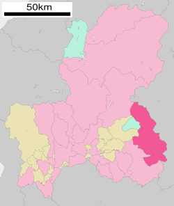
 Location of Nakatsugawa in Gifu Prefecture | |
| Coordinates: 35°29′15.3″N 137°30′2.1″E / 35.487583°N 137.500583°E | |
| Country | Japan |
| Region | Chūbu |
| Prefecture | Gifu |
| Government | |
| • Mayor | Setsuji Aoyama (since January 2012)[1] |
| Area | |
• Total | 676.45 km2 (261.18 sq mi) |
| Population (December 31, 2018) | |
• Total | 78,930 |
| • Density | 120/km2 (300/sq mi) |
| Time zone | UTC+9 (Japan Standard Time) |
| Phone number | 0573-66-1111 |
| Address | Kayanoki-chō 2-1, Nakatsugawa-shi, Gifu-ken 508-8501 |
| Climate | Cfa |
| Website | Official website |
| Symbols | |
| Flower | Enkianthus campanulatus |
| Tree | Sciadopitys verticillata |

Geography
editNakatsugawa is in the Tōnō region of far eastern Gifu Prefecture, bordering on Nagano Prefecture. Mount Ena, the southernmost of the Kiso Mountains on the border between Nakatsugawa, Aichi and Nagano Prefecture is the highest point in the city, with an elevation of 2,191 metres (7,188 ft). The Kiso River and the Agi River flow through the city.
Climate
editThe city has a climate characterized by hot and humid summers, and mild winters (Köppen climate classification Cfa). The average annual temperature in Nakatsugawa is 13.5 °C (56.3 °F). The average annual rainfall is 1,907.1 mm (75.08 in) with July as the wettest month. The temperatures are highest on average in August, at around 26.1 °C (79.0 °F), and lowest in January, at around 1.1 °C (34.0 °F).[3]
| Climate data for Nakatsugawa (2010−2020 normals, extremes 2010−present) | |||||||||||||
|---|---|---|---|---|---|---|---|---|---|---|---|---|---|
| Month | Jan | Feb | Mar | Apr | May | Jun | Jul | Aug | Sep | Oct | Nov | Dec | Year |
| Record high °C (°F) | 14.8 (58.6) |
19.0 (66.2) |
24.1 (75.4) |
29.2 (84.6) |
32.6 (90.7) |
35.1 (95.2) |
39.2 (102.6) |
38.8 (101.8) |
36.5 (97.7) |
31.3 (88.3) |
23.8 (74.8) |
21.8 (71.2) |
39.2 (102.6) |
| Mean daily maximum °C (°F) | 6.9 (44.4) |
8.6 (47.5) |
13.5 (56.3) |
18.6 (65.5) |
24.4 (75.9) |
27.0 (80.6) |
30.6 (87.1) |
32.4 (90.3) |
28.0 (82.4) |
22.2 (72.0) |
15.8 (60.4) |
9.2 (48.6) |
19.8 (67.6) |
| Daily mean °C (°F) | 1.1 (34.0) |
2.3 (36.1) |
6.5 (43.7) |
11.7 (53.1) |
17.5 (63.5) |
21.0 (69.8) |
25.0 (77.0) |
26.1 (79.0) |
22.1 (71.8) |
16.1 (61.0) |
9.4 (48.9) |
3.6 (38.5) |
13.5 (56.4) |
| Mean daily minimum °C (°F) | −3.5 (25.7) |
−2.7 (27.1) |
0.7 (33.3) |
5.5 (41.9) |
11.1 (52.0) |
16.4 (61.5) |
20.9 (69.6) |
21.9 (71.4) |
17.7 (63.9) |
11.4 (52.5) |
4.3 (39.7) |
−0.8 (30.6) |
8.6 (47.4) |
| Record low °C (°F) | −10.4 (13.3) |
−10.2 (13.6) |
−6.8 (19.8) |
−4.2 (24.4) |
1.3 (34.3) |
7.6 (45.7) |
16.5 (61.7) |
15.8 (60.4) |
7.9 (46.2) |
0.7 (33.3) |
−3.1 (26.4) |
−8.4 (16.9) |
−10.4 (13.3) |
| Average precipitation mm (inches) | 59.0 (2.32) |
90.6 (3.57) |
141.0 (5.55) |
165.3 (6.51) |
153.8 (6.06) |
219.5 (8.64) |
289.7 (11.41) |
240.1 (9.45) |
241.8 (9.52) |
178.5 (7.03) |
91.4 (3.60) |
76.1 (3.00) |
1,907.1 (75.08) |
| Average precipitation days (≥ 1.0 mm) | 5.9 | 7.7 | 10.1 | 10.5 | 9.9 | 13.8 | 15.5 | 12.9 | 11.6 | 9.9 | 7.5 | 8.7 | 124 |
| Mean monthly sunshine hours | 160.8 | 160.9 | 195.3 | 191.2 | 230.3 | 157.3 | 167.8 | 195.3 | 160.1 | 164.4 | 154.6 | 137.3 | 2,077.9 |
| Source: Japan Meteorological Agency[3][4] | |||||||||||||
Neighbouring municipalities
editDemographics
editPer Japanese census data,[5] the population of Nakatsugawa peaked around the year 2000 and has declined since.
| Year | Pop. | ±% |
|---|---|---|
| 1970 | 79,593 | — |
| 1980 | 83,539 | +5.0% |
| 1990 | 84,410 | +1.0% |
| 2000 | 85,004 | +0.7% |
| 2010 | 80,910 | −4.8% |
| 2020 | 76,570 | −5.4% |
History
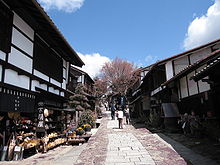
editThe area around Nakatsugawa was part of traditional Mino Province. During the Edo period, much of the area was under the control of Owari Domain, Naegi Domain and Iwamura Domain, or was tenryō under direction control of the Tokugawa shogunate. Nakatsugawa-juku prospered as one of the 69 Stations of the Nakasendō along the Nakasendō highway connecting Edo with Kyoto. In the post-Meiji restoration cadastral reforms, Ena District in Gifu prefecture was created, and Nakatsugawa was proclaimed a town per the April 1, 1897 establishment of the modern municipalities system. Nakatsugawa merged with the town of Naegi in 1951 and was elevated to city status on April 1, 1952. Nakatsugawa annexed the village of Nakamoto in 1954, Ochiai in 1956, and Agi in 1957. On February 13, 2005, the towns of Tsukechi, Fukuoka and Sakashita and the villages of Hirukawa, Kashimo and Kawaue (all from the former Ena District), and the village of Yamaguchi (from Kiso District, Nagano Prefecture) were merged into Nakatsugawa.[6]
Government
editNakatsugawa has a mayor-council form of government with a directly elected mayor and a unicameral city legislature of 24 members.
Education
editColleges and universities
edit- Chukyo Gakuin University
- Nagoya University - Nakatsugawa campus
Primary and secondary education
editNakatsugawa has 19 public elementary schools and 12 public middle schools operated by the city government. The city has four public high schools operated by the Gifu Prefectural Board of Education, and one public high school operated by the city government.
Transportation
editRailway
edit- - JR Central - Chūō Main Line
- Akechi Railway (Akechi Line)
Highway
editSister cities
edit- International
- Domestic
Local attractions
edit- Kurikinton - Nakatsugawa is known for its abundant chestnut harvest and the chestnut delicacy known as kurikinton (栗きんとん). Kurikinton is produced by boiling and mashing the chestnuts, then mixing them with sugar and reforming into a chestnut shape. It is widely available during the autumn months. Many families make their own, while purchased kurikinton is popular as well for home consumption and as gifts.
- Misaka Pass, a National Historic Site
- Takamine Co., a Japanese guitar manufacturer known for its steel-string acoustic guitars is headquartered in Nakatsugawa.
Notable people from Nakatsugawa
edit- Junji Ito, horror mangaka
- Seison Maeda, Nihonga painter
References
edit- ^ 市長の部屋/中津川市 [Mayor's Room]. Nakatsugawa official page (in Japanese). Retrieved 1 September 2022.
- ^ Nakatsugawa official statistics (in Japanese)
- ^ a b 気象庁 / 平年値(年・月ごとの値). JMA. Retrieved May 30, 2022.
- ^ 観測史上1~10位の値(年間を通じての値). JMA. Retrieved May 30, 2022.
- ^ Nakatsugawa population statistics
- ^ "中津川市紹介(HP版)07.03.27" (PDF). Nakatsugawa official website (in Japanese). Retrieved August 19, 2011.
External links
edit- Media related to Nakatsugawa, Gifu at Wikimedia Commons
- Official website (in Japanese)


