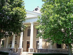
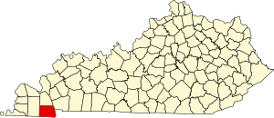
Calloway County is a county located on the southwest border of the U.S. Commonwealth of Kentucky. As of the 2020 census, the population was 37,103.[1] Its county seat is Murray.[2] The county was founded in November 1822 and named for Colonel Richard Callaway, one of the founders of Boonesborough.[3] Calloway County comprises the Murray, KY Micropolitan Statistical Area. As of July 18, 2012[update] Calloway County is a moist county: the sale of alcohol in the county is prohibited, with the exception of the city of Murray.
Calloway County | |
|---|---|
 Calloway County courthouse in Murray | |
 Location within the U.S. state of Kentucky | |
 Kentucky's location within the U.S. | |
| Coordinates: 36°37′N 88°16′W / 36.62°N 88.27°W | |
| Country | |
| State | |
| Founded | November 3, 1822 |
| Named for | Richard Callaway |
| Seat | Murray |
| Largest city | Murray |
| Area | |
• Total | 411 sq mi (1,060 km2) |
| • Land | 385 sq mi (1,000 km2) |
| • Water | 26 sq mi (70 km2) 6.3% |
| Population (2020) | |
• Total | 37,103 |
• Estimate (2023) | 38,280 |
| • Density | 90/sq mi (35/km2) |
| Time zone | UTC−6 (Central) |
| • Summer (DST) | UTC−5 (CDT) |
| Congressional district | 1st |
| Website | callowaycountyky |
History
editCalloway County was created in 1822 from land taken from Hickman County. The courthouse was built in 1823. A fire at the courthouse in 1906 caused the almost complete destruction of the county records.[4] Calloway county was named after Richard Callaway.[5]
Geography
editAccording to the United States Census Bureau, the county has a total area of 411 square miles (1,060 km2), of which 385 square miles (1,000 km2) is land and 26 square miles (67 km2) (6.3%) is water.[6]
Adjacent counties
edit- Marshall County (north)
- Trigg County (northeast)
- Stewart County, Tennessee (southeast)
- Henry County, Tennessee (south)
- Graves County (west)
National protected area
edit- Fort Donelson National Battlefield (Fort Heiman part)
Demographics
edit| Census | Pop. | Note | %± |
|---|---|---|---|
| 1830 | 5,164 | — | |
| 1840 | 9,794 | 89.7% | |
| 1850 | 8,096 | −17.3% | |
| 1860 | 9,915 | 22.5% | |
| 1870 | 9,410 | −5.1% | |
| 1880 | 13,295 | 41.3% | |
| 1890 | 14,675 | 10.4% | |
| 1900 | 17,633 | 20.2% | |
| 1910 | 19,867 | 12.7% | |
| 1920 | 20,802 | 4.7% | |
| 1930 | 17,662 | −15.1% | |
| 1940 | 19,041 | 7.8% | |
| 1950 | 20,147 | 5.8% | |
| 1960 | 20,972 | 4.1% | |
| 1970 | 27,692 | 32.0% | |
| 1980 | 30,031 | 8.4% | |
| 1990 | 30,735 | 2.3% | |
| 2000 | 34,177 | 11.2% | |
| 2010 | 37,191 | 8.8% | |
| 2020 | 37,103 | −0.2% | |
| 2023 (est.) | 38,280 | [7] | 3.2% |
| U.S. Decennial Census[8] 1790-1960[9] 1900-1990[10] 1990-2000[11] 2010-2020[1] | |||
As of the census[12] of 2000, there were 34,177 people, 13,862 households, and 8,594 families residing in the county. The population density was 88 per square mile (34/km2). There were 16,069 housing units at an average density of 42 per square mile (16/km2). The racial makeup of the county was 93.48% White, 3.56% Black or African American, 0.20% Native American, 1.33% Asian, 0.03% Pacific Islander, 0.46% from other races, and 0.93% from two or more races. 1.38% of the population were Hispanic or Latino of any race.
There were 13,862 households, out of which 25.80% had children under the age of 18 living with them, 51.00% were married couples living together, 8.10% had a female householder with no husband present, and 38.00% were non-families. 29.70% of all households were made up of individuals, and 11.40% had someone living alone who was 65 years of age or older. The average household size was 2.25 and the average family size was 2.79.
The age distribution was 18.70% under the age of 18, 19.80% from 18 to 24, 24.60% from 25 to 44, 21.90% from 45 to 64, and 15.00% who were 65 years of age or older. The median age was 34 years. The relatively large 18-to-24 population is mostly due to the presence of Murray State University. For every 100 females there were 93.20 males. For every 100 females age 18 and over, there were 91.00 males.
The median income for a household in the county was $30,134, and the median income for a family was $39,914. Males had a median income of $31,184 versus $22,046 for females. The per capita income for the county was $16,566. About 9.80% of families and 16.60% of the population were below the poverty line, including 17.70% of those under age 18 and 10.00% of those age 65 or over.
Politics
edit| Year | Republican | Democratic | Third party(ies) | |||
|---|---|---|---|---|---|---|
| No. | % | No. | % | No. | % | |
| 2024 | 11,539 | 68.10% | 5,111 | 30.16% | 295 | 1.74% |
| 2020 | 11,352 | 65.03% | 5,797 | 33.21% | 308 | 1.76% |
| 2016 | 10,367 | 64.60% | 4,749 | 29.59% | 933 | 5.81% |
| 2012 | 9,440 | 62.63% | 5,317 | 35.28% | 315 | 2.09% |
| 2008 | 8,991 | 58.37% | 6,165 | 40.02% | 248 | 1.61% |
| 2004 | 9,293 | 61.36% | 5,728 | 37.82% | 124 | 0.82% |
| 2000 | 7,705 | 56.35% | 5,635 | 41.21% | 333 | 2.44% |
| 1996 | 4,989 | 43.14% | 5,281 | 45.66% | 1,296 | 11.21% |
| 1992 | 4,654 | 36.53% | 6,181 | 48.52% | 1,905 | 14.95% |
| 1988 | 6,225 | 53.91% | 5,287 | 45.79% | 34 | 0.29% |
| 1984 | 6,442 | 55.94% | 5,028 | 43.66% | 45 | 0.39% |
| 1980 | 4,498 | 37.60% | 6,809 | 56.91% | 657 | 5.49% |
| 1976 | 3,171 | 27.56% | 8,141 | 70.75% | 195 | 1.69% |
| 1972 | 5,167 | 59.17% | 3,468 | 39.72% | 97 | 1.11% |
| 1968 | 2,672 | 30.78% | 3,854 | 44.39% | 2,156 | 24.83% |
| 1964 | 1,576 | 17.74% | 7,290 | 82.04% | 20 | 0.23% |
| 1960 | 3,356 | 41.69% | 4,693 | 58.31% | 0 | 0.00% |
| 1956 | 2,292 | 27.09% | 6,152 | 72.72% | 16 | 0.19% |
| 1952 | 1,829 | 25.14% | 5,434 | 74.69% | 12 | 0.16% |
| 1948 | 681 | 11.82% | 4,896 | 85.01% | 182 | 3.16% |
| 1944 | 1,121 | 18.60% | 4,888 | 81.12% | 17 | 0.28% |
| 1940 | 896 | 13.38% | 5,793 | 86.49% | 9 | 0.13% |
| 1936 | 939 | 14.51% | 5,523 | 85.34% | 10 | 0.15% |
| 1932 | 813 | 11.32% | 6,335 | 88.18% | 36 | 0.50% |
| 1928 | 1,557 | 31.13% | 3,431 | 68.59% | 14 | 0.28% |
| 1924 | 936 | 19.17% | 3,790 | 77.63% | 156 | 3.20% |
| 1920 | 1,520 | 24.19% | 4,574 | 72.79% | 190 | 3.02% |
| 1916 | 1,026 | 22.73% | 3,334 | 73.88% | 153 | 3.39% |
| 1912 | 628 | 17.49% | 2,380 | 66.28% | 583 | 16.24% |
Communities
editCities
editCensus-designated place
editOther unincorporated communities
editPlace of interest
edit- Fort Heiman, part of Fort Donelson National Battlefield
Notable people
edit- W. Earl Brown, actor/musician
- T.R.M. Howard, surgeon, civil rights leader and entrepreneur
- Joe Staton, cartoonist
- Frank Stubblefield, politician
- Nathan Stubblefield, inventor
- Harry Lee Waterfield, politician
- Molly Sims, actress/model
- Cleanth Brooks, professor, literary critic
- Mel Purcell, professional tennis player
- Jackie DeShannon, 1960s singer-songwriter
- Tim Masthay, NFL Punter, Super Bowl Champion
See also
editReferences
edit- ^ a b "State & County QuickFacts". United States Census Bureau. Retrieved July 7, 2022.
- ^ "Find a County". National Association of Counties. Archived from the original on May 31, 2011. Retrieved June 7, 2011.
- ^ "Calloway County". The Kentucky Encyclopedia. 2000. Archived from the original on September 30, 2018. Retrieved August 21, 2014.
- ^ Hogan, Roseann Reinemuth (1992). Kentucky Ancestry: A Guide to Genealogical and Historical Research. Ancestry Publishing. p. 207. ISBN 9780916489496. Retrieved July 26, 2013.
- ^ "Murray, Kentucky History". www.explorekentuckylake.com. Retrieved April 23, 2016.
- ^ "2010 Census Gazetteer Files". United States Census Bureau. August 22, 2012. Archived from the original on August 12, 2014. Retrieved August 13, 2014.
- ^ "Annual Estimates of the Resident Population for Counties: April 1, 2020 to July 1, 2023". United States Census Bureau. Retrieved March 14, 2024.
- ^ "U.S. Decennial Census". United States Census Bureau. Retrieved August 13, 2014.
- ^ "Historical Census Browser". University of Virginia Library. Retrieved August 13, 2014.
- ^ "Population of Counties by Decennial Census: 1900 to 1990". United States Census Bureau. Retrieved August 13, 2014.
- ^ "Census 2000 PHC-T-4. Ranking Tables for Counties: 1990 and 2000" (PDF). United States Census Bureau. Archived (PDF) from the original on March 27, 2010. Retrieved August 13, 2014.
- ^ "U.S. Census website". United States Census Bureau. Retrieved January 31, 2008.
- ^ Leip, David. "Dave Leip's Atlas of U.S. Presidential Elections". uselectionatlas.org. Retrieved February 22, 2021.

