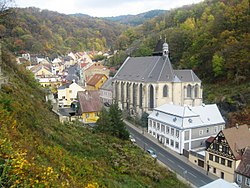
Krupka (Czech pronunciation: [ˈkrupka]; German: Graupen) is a town in Teplice District in the Ústí nad Labem Region of the Czech Republic. It has about 13,000 inhabitants. The town is located in the Ore Mountain Mining Region, a UNESCO World Heritage Site, and during the late Middle Ages it was one of the world-leading producers of tin and silver.[2] The centre of Krupka is well preserved and is protected by law as an urban monument zone.
Krupka | |
|---|---|
 Historic centre of Krupka | |
| Coordinates: 50°41′4″N 13°51′30″E / 50.68444°N 13.85833°E | |
| Country | |
| Region | Ústí nad Labem |
| District | Teplice |
| First mentioned | 1305 |
| Government | |
| • Mayor | Jan Kuzma (ANO) |
| Area | |
• Total | 46.61 km2 (18.00 sq mi) |
| Elevation | 300 m (1,000 ft) |
| Population (2024-01-01)[1] | |
• Total | 12,779 |
| • Density | 270/km2 (710/sq mi) |
| Time zone | UTC+1 (CET) |
| • Summer (DST) | UTC+2 (CEST) |
| Postal code | 417 42 |
| Website | www |
Administrative parts
editThe town parts and villages of Bohosudov, Fojtovice, Horní Krupka, Maršov, Nové Modlany, Soběchleby, Unčín and Vrchoslav are administrative parts of Krupka.
Etymology
editThe name Krupka was derived from the old Czech adjective krupá, which means 'rough'. Krupá was a name of a nearby hill. The German name Graupen was created by transcription of the Czech name.[3]
Geography
editKrupka is located about 3 kilometres (2 mi) north of Teplice and 11 km (7 mi) east of Ústí nad Labem. The southern part of the municipal territory with the built-up area lies the Most Basin, the northern part lies in the Ore Mountains.
On the southern border of Krupka there is the Kateřina Reservoir, built at the beginning of the 20th century. It was built as part of water management protection and today it is also used for recreational purposes.[4]
History
editThe origin of the original mining town is connected with the mining of tin ore and its further processing. The first written mention of Krupka is from 1305 in a deed of King Wenceslaus II. In 1330, existence of a guard fortress is mentioned. After the Hussite Wars, Krupka gained town privileges.[5]
In the 17th century, problems with mining activities began to appear, and tin sales were stuck. The Thirty Years' War adversely affected mining. In 1708, the Clary-Aldringen family purchased the Krupka estate and owned it until 1918.[5]
In the 19th century, the economic centre moved to neighbouring Bohosudov with the establishment of new factories and lignite mines. In 1858, the railway to Bohosudov was built. In 1898, Bohosudov was promoted to a town. From 1938 to 1945, Krupka was annexed by Nazi Germany and administered as part of the Reichsgau Sudetenland. In 1960, Bohosudov was merged with Krupka and became its most populated town part.[5]
Demographics
edit
|
|
| ||||||||||||||||||||||||||||||||||||||||||||||||||||||
| Source: Censuses[6][7] | ||||||||||||||||||||||||||||||||||||||||||||||||||||||||
Transport
editTwo railway lines passes through Krupka: Děčín–Kadaň and Ústí nad Labem – Litvínov. The train station is named Krupka-Bohosudov.[8]
Sport
editThe town is home to the association football team FK Krupka, which plas in lower amateur tiers. The table tennis club has a long tradition in Krupka. Other organized sports in Krupka are athletics, swimming, floorball and bicross.[9] The athletics stadium known as the TJ Baník stadium previously hosted motorcycle speedway from 1958 to 1966[10] and hosted a final round of the Czechoslovak Individual Speedway Championship for four consecutive years from 1959 to 1962.[11]
Sights
editThe historic centre of Krupka is made up of Husitská Street, formerly the seat of various craftsmen. Today's appearance of the street consists of rebuilt or reconstructed originally Renaissance houses. The main landmark is the Church of the Assumption of the Virgin Mary from the 14th century. It was destroyed by fires many times and restored in 1668. Behind the church there is a bell tower from the 15th century. Above the church, there is the former town hall, today privately owned.[12]
The Church of the Holy Spirit was built in 1440–1454, originally in the Gothic style. The third church in the street is the Church of Saint Wenceslaus from 1901. Above the street, there is the ruin of Krupka Castle. Only the massive walls have been preserved. It serves as a view point.[12]
The big statue of Saint Francis Xavier belongs to the symbols of the town. It is a Baroque statue from 1717. It was built to commemorate the retreat of the plague.[12]
The mining cultural landscape of Krupka was designated a UNESCO World Heritage Site in 2019 as part of the transnational Ore Mountain Mining Region.[13] In connection with the mining, there was created an educational pathway leading from the Czech side to the German side and showing various historically important sites.[14] In Husitská Street, there is the Infocentre of Krupka Mining Region with an exposition focused on history and life in Krupka, mining in the Ore Mountains, and an ore collection.[15]
The Basilica of Our Lady of Sorrows is the most significant building in Bohosudov. It was built in the Baroque style by Octavio Broggio in 1701–1709 and has a pilgrimage tradition. It is protected as a national cultural monument.[16]
Notable people
edit- Carl Ferdinand von Arlt (1812–1887), Austrian ophthalmologist
- Herta Lindner (1920–1943), German resistance fighter
- Radim Breite (born 1989), footballer
Twin towns – sister cities
edit- Geising (Altenberg), Germany
References
edit- ^ "Population of Municipalities – 1 January 2024". Czech Statistical Office. 2024-05-17.
- ^ International Council on Monuments and Sites (13 March 2019). Erzgebirge/Krušnohoří(Germany/Czechia) No 1478 (Report). Retrieved 11 June 2021.
- ^ Profous, Antonín (1949). Místní jména v Čechách II: CH–L (in Czech). pp. 425–427.
- ^ "Vodní nádrž Kateřina – Krupská pláž" (in Czech). CzechTourism. Retrieved 2022-07-31.
- ^ a b c "Historie města" (in Czech). Město Krupka. Retrieved 2021-07-17.
- ^ "Historický lexikon obcí České republiky 1869–2011" (in Czech). Czech Statistical Office. 2015-12-21.
- ^ "Population Census 2021: Population by sex". Public Database. Czech Statistical Office. 2021-03-27.
- ^ "Detail stanice Krupka-Bohosudov" (in Czech). České dráhy. Retrieved 2023-06-29.
- ^ "Sportovní kluby" (in Czech). Město Krupka. Retrieved 2024-05-19.
- ^ "Abeceda ploché dráhy – písmeno "K"". speedwayfakta.cz (in Czech). Retrieved 2024-03-30.
- ^ "Individual Czechoslovak Championship". historyspeedway.nstrefa.pl (in Polish). Retrieved 2024-03-30.
- ^ a b c "Městská památková zóna - Husitská ulice" (in Czech). Město Krupka. Retrieved 2021-07-17.
- ^ "Erzgebirge/Krušnohoří Mining Region". UNESCO. Retrieved 2023-01-23.
- ^ "Turistické trasy, stezky" (in Czech). Město Krupka. Retrieved 2021-07-17.
- ^ "Infocentrum Hornické krajiny Krupka" (in Czech). Město Krupka. Retrieved 2021-07-17.
- ^ "Kostel Panny Marie Bolestné" (in Czech). National Heritage Institute. Retrieved 2023-01-23.
- ^ "Spolupráce měst" (in Czech). Město Krupka. Retrieved 2021-07-17.


