Guanling Buyei and Miao Autonomous County (simplified Chinese: 关岭布依族苗族自治县; traditional Chinese: 關嶺布依族苗族自治縣; Bouyei: Gvanylingj Buxqyaix Buxyeeuz Ziqziqxianq) is an autonomous county in Anshun City, in the southwest of Guizhou Province, China.
Guanling County
关岭县 · Gvanylingj xianq | |
|---|---|
| 关岭布衣族苗族自治县 Gvanylingj Buxqyaix Buxyeeuz Ziqziqxianq Guanling Buyei and Miao Autonomous County | |
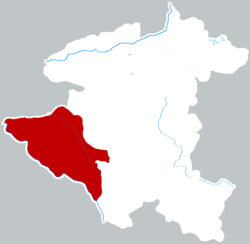
 Guanling is the westernmost division on this map of Anshun | |
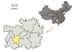
 Anshun in Guizhou | |
| Coordinates (Guanling County government): 25°57′13″N 105°32′18″E / 25.9535°N 105.5383°E[1] | |
| Country | China |
| Province | Guizhou |
| Prefecture-level city | Anshun |
| County seat | Guansuo Subdistrict |
| Area | |
| • Total | 1,470.49 km2 (567.76 sq mi) |
| Population (2020 census)[2] | |
| • Total | 283,497 |
| • Density | 190/km2 (500/sq mi) |
| Time zone | UTC+8 (China Standard) |
| Website | www |
Administrative divisions
editGuanling is divided into 4 subdistricts, 9 towns and 1 township:[3]
- subdistricts
- Dingyun Subdistrict (顶云街道)
- Guansuo Subdistrict (关索街道)
- Longtan Subdistrict (龙潭街道)
- Baihe Subdistrict (百合街道)
- towns
- Huajiang Town (花江镇)
- Yongning Town (永宁镇)
- Gangwu Town (岗乌镇)
- Shangguan Town (上关镇)
- Pogong Town (坡贡镇)
- Duanqiao Town (断桥镇)
- Baishui Town (白水镇)
- Shaying Town (沙营镇)
- Xinpu Town (新铺镇)
- townships
- Puli Township (普利乡)
Transportation
editClimate
edit| Climate data for Guanling, elevation 1,142 m (3,747 ft), (1991–2020 normals, extremes 1981–2010) | |||||||||||||
|---|---|---|---|---|---|---|---|---|---|---|---|---|---|
| Month | Jan | Feb | Mar | Apr | May | Jun | Jul | Aug | Sep | Oct | Nov | Dec | Year |
| Record high °C (°F) | 26.0 (78.8) |
30.7 (87.3) |
35.3 (95.5) |
35.3 (95.5) |
35.9 (96.6) |
33.5 (92.3) |
33.3 (91.9) |
33.6 (92.5) |
33.9 (93.0) |
29.8 (85.6) |
26.4 (79.5) |
23.5 (74.3) |
35.9 (96.6) |
| Mean daily maximum °C (°F) | 10.1 (50.2) |
13.5 (56.3) |
18.1 (64.6) |
23.2 (73.8) |
25.6 (78.1) |
26.5 (79.7) |
27.9 (82.2) |
28.3 (82.9) |
25.8 (78.4) |
20.9 (69.6) |
17.3 (63.1) |
11.9 (53.4) |
20.8 (69.4) |
| Daily mean °C (°F) | 6.9 (44.4) |
9.5 (49.1) |
13.3 (55.9) |
18.1 (64.6) |
20.8 (69.4) |
22.5 (72.5) |
23.6 (74.5) |
23.4 (74.1) |
21.1 (70.0) |
17.2 (63.0) |
13.2 (55.8) |
8.4 (47.1) |
16.5 (61.7) |
| Mean daily minimum °C (°F) | 4.6 (40.3) |
6.6 (43.9) |
9.9 (49.8) |
14.3 (57.7) |
17.3 (63.1) |
19.6 (67.3) |
20.7 (69.3) |
20.1 (68.2) |
17.9 (64.2) |
14.6 (58.3) |
10.4 (50.7) |
6.0 (42.8) |
13.5 (56.3) |
| Record low °C (°F) | −3.4 (25.9) |
−1.6 (29.1) |
−0.9 (30.4) |
4.2 (39.6) |
8.7 (47.7) |
12.9 (55.2) |
13.0 (55.4) |
15.2 (59.4) |
8.9 (48.0) |
6.0 (42.8) |
−0.9 (30.4) |
−5.7 (21.7) |
−5.7 (21.7) |
| Average precipitation mm (inches) | 30.0 (1.18) |
19.5 (0.77) |
36.1 (1.42) |
66.5 (2.62) |
160.2 (6.31) |
296.8 (11.69) |
271.7 (10.70) |
184.8 (7.28) |
133.0 (5.24) |
93.4 (3.68) |
34.3 (1.35) |
19.7 (0.78) |
1,346 (53.02) |
| Average precipitation days (≥ 0.1 mm) | 14.8 | 11.7 | 12.9 | 13.2 | 15.8 | 18.8 | 18.0 | 16.5 | 12.9 | 15.8 | 10.5 | 11.6 | 172.5 |
| Average snowy days | 1.9 | 0.7 | 0.2 | 0 | 0 | 0 | 0 | 0 | 0 | 0 | 0 | 0.4 | 3.2 |
| Average relative humidity (%) | 82 | 77 | 75 | 73 | 75 | 82 | 83 | 81 | 79 | 81 | 80 | 79 | 79 |
| Mean monthly sunshine hours | 44.6 | 67.1 | 99.1 | 135.4 | 140.8 | 110.3 | 154.3 | 175.1 | 135.4 | 82.9 | 93.9 | 61.0 | 1,299.9 |
| Percent possible sunshine | 13 | 21 | 27 | 35 | 34 | 27 | 37 | 44 | 37 | 23 | 29 | 19 | 29 |
| Source: China Meteorological Administration[4][5] | |||||||||||||
References
edit- ^ 关岭自治县人民政府政务服务中心 - 高德地图. Amap. Retrieved 2020-05-24.
- ^ "安顺市第七次全国人口普查公报(第一号)——全市人口情况" (in Chinese). Government of Anshun. 2021-06-09. Archived from the original on 2021-10-10. Retrieved 2023-09-10.
- ^ 2023年统计用区划代码和城乡划分代码:关岭布依族苗族自治县 (in Simplified Chinese). National Bureau of Statistics of China.
- ^ 中国气象数据网 – WeatherBk Data (in Simplified Chinese). China Meteorological Administration. Retrieved 28 April 2023.
- ^ 中国气象数据网 (in Simplified Chinese). China Meteorological Administration. Retrieved 28 April 2023.

