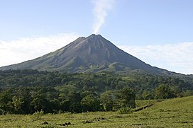
The Cordillera de Guanacaste, also called Guanacaste Cordillera, are a volcanic mountain range in northern Costa Rica near the border with Nicaragua. The mountain range stretches 110 km from northwest to the southeast and contains mostly complex stratovolcanoes.[1] The range forms part of the southern region of the Continental Divide, with the highest peak is the stratovolcano Miravalles at 2,028 m.[2]
| Cordillera de Guanacaste | |
|---|---|
| Guanacaste Range | |
 Arenal volcano | |
| Highest point | |
| Peak | Miravalles Volcano |
| Elevation | 2,028 m (6,654 ft) |
| Coordinates | 10°44′54″N 85°9′10″W / 10.74833°N 85.15278°W |
| Geography | |
 | |
| Country | Costa Rica |
| Parent range | Central America Volcanic Arc |
| Biome | Atlantic rainforest, lowlands |
| Geology | |
| Rock age | Quaternary |
Rivers flowing from the range drain into the Caribbean Sea (Guacalito, Zapote) and the Pacific Ocean (Blanco, Tenorio, Martirio, Corobiá and San Lorenzo).
Protected areas located in the mountain range include Guanacaste National Park established in July 1991[3] and Area de Conservación Guanacaste World Heritage Site inscribed by UNESCO as a World Heritage Site in December 1999.[4]
The range contains areas of ecological significance, as the Miravalles Forest Reserve, hills and canyons that can be seen from the lowlands of Guanacaste, areas rich with epiphytes, ferns and palms; and areas of geothermal activity, exploited for energy use. Geothermal energy exploited in Guanacaste account to 18% of Costa Rica's electricity and is also exported to Nicaragua and Panama.[2]
Cordillera de Guanacaste is divided into two sections:[5]
- La Cordillera Volcánica - formed by a series of volcanic edifices that begin with the Orosi Volcano and ends with the Arenal Volcano.
- La Sierra Minera - depressions located between Arenal and Tapezco.
Notable peaks
edit- Miravalles Volcano - 2,028 metres (6,654 ft)
- Rincón de la Vieja Volcano - 1,916 metres (6,286 ft)
- Tenorio Volcano - 1,916 metres (6,286 ft)
- Orosí Volcano - 1,659 metres (5,443 ft)
- Arenal Volcano - 1,670 metres (5,480 ft)[6]
References
edit- ^ Alvarado Induni, Guillermo E.; Oscar Luis Chavarría-Aguilar (2005). Costa Rica: Land of Volcanoes (2nd ed.). San José, Costa Rica: EUNED. p. 57. ISBN 9968-31-366-1.
- ^ a b Firestone, Matthew; Wendy Yanagihara; Mara Vorhees (2008). Costa Rica (8th ed.). London: Lonely Planet. p. 206. ISBN 978-1-74104-885-8.
- ^ Alvarado Induni, Guillermo E.; Oscar Luis Chavarría-Aguilar (2005). Costa Rica: Land of Volcanoes (2nd ed.). San José, Costa Rica: EUNED. p. 61. ISBN 9968-31-366-1.
- ^ "Area de Conservación Guanacaste, Costa Rica" (PDF). (288 KB) at United Nations Environment Programme - World Conservation Monitoring Centre website ()
- ^ Sistema Montaňoso de Costa Rica Archived 2010-03-05 at the Wayback Machine
- ^ Arenal Volcano lies of the edge of Cordillera Guanacaste and Cordillera de Tilarán