Size of this preview: 699 × 600 pixels. Other resolutions: 280 × 240 pixels | 560 × 480 pixels | 1,000 × 858 pixels.
Original file (1,000 × 858 pixels, file size: 351 KB, MIME type: image/png)
File history
Click on a date/time to view the file as it appeared at that time.
| Date/Time | Thumbnail | Dimensions | User | Comment | |
|---|---|---|---|---|---|
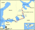
| current | 17:59, 6 December 2005 |  | 1,000 × 858 (351 KB) | NormanEinstein | This map shows the route of the White Sea-Baltic Sea Canal between the White Sea and Baltic Sea. (Heh heh.) It shows the lakes Vygozero, Onega, and Ladoga, and the Sivr and Neva rivers too. Created by NormanEinstein, December 6, 2005. {{GFDL-self}} [[C |
File usage
The following 6 pages use this file:
Global file usage
The following other wikis use this file:
- Usage on af.wiki.x.io
- Usage on ar.wiki.x.io
- Usage on arz.wiki.x.io
- Usage on ast.wiki.x.io
- Usage on bg.wiki.x.io
- Usage on ca.wiki.x.io
- Usage on cs.wiki.x.io
- Usage on da.wiki.x.io
- Usage on es.wiki.x.io
- Usage on fa.wiki.x.io
- Usage on fr.wiki.x.io
- Usage on fy.wiki.x.io
- Usage on hi.wiki.x.io
- Usage on id.wiki.x.io
- Usage on incubator.wikimedia.org
- Usage on is.wiki.x.io
- Usage on it.wiki.x.io
- Usage on ja.wiki.x.io
- Usage on ko.wiki.x.io
- Usage on lt.wiki.x.io
- Usage on lv.wiki.x.io
- Usage on mk.wiki.x.io
- Usage on nl.wiki.x.io
- Usage on no.wiki.x.io
- Usage on pl.wiki.x.io
- Usage on pt.wiki.x.io
- Usage on qu.wiki.x.io
- Usage on ro.wiki.x.io
- Usage on ru.wiki.x.io
- Usage on simple.wiki.x.io
- Usage on sl.wiki.x.io
- Usage on sq.wiki.x.io
- Usage on sv.wiki.x.io
- Usage on th.wiki.x.io
- Usage on tr.wiki.x.io
- Usage on ur.wiki.x.io
View more global usage of this file.


