
Size of this PNG preview of this SVG file: 620 × 600 pixels. Other resolutions: 248 × 240 pixels | 496 × 480 pixels | 794 × 768 pixels | 1,059 × 1,024 pixels | 2,118 × 2,048 pixels | 819 × 792 pixels.
Original file (SVG file, nominally 819 × 792 pixels, file size: 5.35 MB)
| This is a file from the Wikimedia Commons. Information from its description page there is shown below. Commons is a freely licensed media file repository. You can help. |
Summary
| Description |
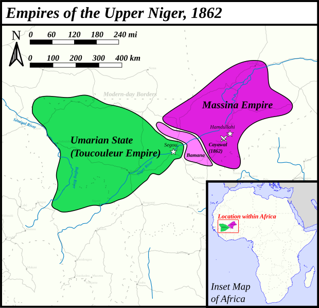
English: This map was made for the article 'Battle of Cayawal' on wikipedia. It gives rough borders of the Umarian State (Toucouleur Empire), Massina Empire and their Bamana allies in 1862. Cayawal is highlighted for the important battle that took place there.
This map uses the Mercator projection. Sources are as follows: For Massina Empire borders: Djata, S. A. (1997). The Bamana Empire by the Niger. Markus Wiener Publishers. Map on page xiii. For Umarian State borders: Robinson, D. (1985). The Holy War of Umar Tal. Oxford University Press. Map on page 19. Meanwhile, page 262 confirms the alliance between the Bamana and Massina. |
| Date | |
| Source | Own work |
| Author | HetmanTheResearcher |
Licensing
I, the copyright holder of this work, hereby publish it under the following license:
This file is licensed under the Creative Commons Attribution 4.0 International license.
- You are free:
- to share – to copy, distribute and transmit the work
- to remix – to adapt the work
- Under the following conditions:
- attribution – You must give appropriate credit, provide a link to the license, and indicate if changes were made. You may do so in any reasonable manner, but not in any way that suggests the licensor endorses you or your use.
File history
Click on a date/time to view the file as it appeared at that time.
| Date/Time | Thumbnail | Dimensions | User | Comment | |
|---|---|---|---|---|---|
| current | 23:48, 25 August 2024 | | 819 × 792 (5.35 MB) | HetmanTheResearcher | Colour touch-ups |
| 22:25, 25 August 2024 |  | 819 × 792 (5.36 MB) | HetmanTheResearcher | Forgot to turn roads back on | |
| 22:23, 25 August 2024 |  | 819 × 792 (5.36 MB) | HetmanTheResearcher | Added inset map for reference | |
| 04:33, 25 August 2024 |  | 831 × 643 (5 MB) | HetmanTheResearcher | Changed image title | |
| 04:30, 25 August 2024 |  | 831 × 643 (6.63 MB) | HetmanTheResearcher | Uploaded own work with UploadWizard |
File usage
The following pages on the English Wikipedia use this file (pages on other projects are not listed):