
Size of this preview: 750 × 600 pixels. Other resolutions: 300 × 240 pixels | 601 × 480 pixels | 992 × 793 pixels.
Original file (992 × 793 pixels, file size: 454 KB, MIME type: image/png)
| This is a file from the Wikimedia Commons. Information from its description page there is shown below. Commons is a freely licensed media file repository. You can help. |
Summary
| Description |
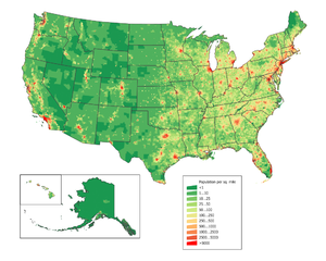
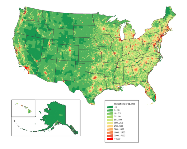
English: United States population density map based on Census 2010 data. See the data lineage for a process description.
Also see U.S. state population maps. |
||||||||
| Source | JimIrwin | ||||||||
| Author | User JimIrwin on en.wikipedia | ||||||||
| Permission (Reusing this file) |
JimIrwin at the English-language Wikipedia, the copyright holder of this work, hereby publishes it under the following license:
|
||||||||
| Other versions |
Originally from en.wikipedia; description page is (was) here * 22:21, 20 March 2006 [[:en:User:JimIrwin|JimIrwin]] 1000×766 (119,253 bytes) <span class="comment">([[:en:Category:U.S. State Population Maps]] [[:en:Category:United States maps]] United States population density map based on Census 2000 data. See the [[:en:data lineage]] for a process description. )</span> |

(Uploaded using CommonsHelper or PushForCommons)
File history
Click on a date/time to view the file as it appeared at that time.
| Date/Time | Thumbnail | Dimensions | User | Comment | |
|---|---|---|---|---|---|
| current | 12:31, 12 December 2011 | | 992 × 793 (454 KB) | JimIrwin | Updated with 2010 census data |
| 15:49, 16 September 2006 |  | 1,000 × 766 (116 KB) | Shizhao | {{Information| |Description= == Summary == en:Category:U.S. State Population Maps en:Category:United States maps United States population density map based on Census 2000 data. See the [[:en:User:JimIrwin/Lineage_of_population_maps|data lineage |
File usage
The following pages on the English Wikipedia use this file (pages on other projects are not listed):
Global file usage
The following other wikis use this file:
- Usage on da.wiki.x.io
- Usage on de.wiki.x.io
- Usage on es.wiki.x.io
- Usage on fa.wiki.x.io
- Usage on fr.wiki.x.io
- Usage on he.wiki.x.io
- Usage on hr.wiki.x.io
- Usage on ht.wiki.x.io
- Usage on incubator.wikimedia.org
- Usage on mg.wiki.x.io
- Usage on mwl.wiki.x.io
- Usage on no.wiki.x.io
- Usage on pcd.wiki.x.io
- Usage on pl.wiki.x.io
- Usage on pt.wiki.x.io
- Usage on sh.wiki.x.io
- Usage on simple.wiki.x.io
- Usage on tl.wiki.x.io
- Usage on trv.wiki.x.io
- Usage on www.wikidata.org
- Usage on zh.wiki.x.io