No higher resolution available.
UA_euro_routes.png (632 × 321 pixels, file size: 53 KB, MIME type: image/png)
| This is a file from the Wikimedia Commons. Information from its description page there is shown below. Commons is a freely licensed media file repository. You can help. |
Summary
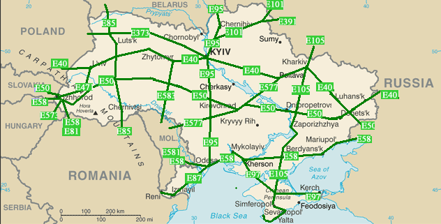
| Description | Maps over the E-roads in Ukraine. Straight lines connect control cities, no attempt to follow the real road. |
| Date | |
| Source | Self-made, based on the CIA factbook maps which is PD |
| Author | Self |
Licensing
I, the copyright holder of this work, hereby publish it under the following license:
This file is licensed under the Creative Commons Attribution-Share Alike 2.5 Generic, 2.0 Generic and 1.0 Generic license.
- You are free:
- to share – to copy, distribute and transmit the work
- to remix – to adapt the work
- Under the following conditions:
- attribution – You must give appropriate credit, provide a link to the license, and indicate if changes were made. You may do so in any reasonable manner, but not in any way that suggests the licensor endorses you or your use.
- share alike – If you remix, transform, or build upon the material, you must distribute your contributions under the same or compatible license as the original.
Original upload log
The original description page was here. All following user names refer to en.wikipedia.
- 2008-03-06 22:50 Bogdan 632×321× (54121 bytes) minor fix
- 2008-03-06 22:46 Bogdan 632×321× (54150 bytes) minor fix
- 2008-03-06 02:37 Bogdan 632×321× (54152 bytes) {{Information |Description=Maps over the [[:en:International E-road network|E-roads]] in Ukraine. |Source=Self-made, based on the CIA factbook maps which is PD |Date=2008-03-05 |Author= Self |other_versions= }} == Licensing == {{self|cc-by-sa-2.5,2.0,1.0
File history
Click on a date/time to view the file as it appeared at that time.
| Date/Time | Thumbnail | Dimensions | User | Comment | |
|---|---|---|---|---|---|
| current | 23:41, 18 February 2011 | | 632 × 321 (53 KB) | OgreBot | (BOT): Reverting to the most recent version before uploads (originally uploaded on 2008-03-06 22:50 by Bogdan. |
| 23:41, 18 February 2011 |  | 632 × 321 (53 KB) | OgreBot | (BOT): This is the version originally uploaded on 2008-03-06 22:46 by Bogdan; storing on commons for archival purposes | |
| 23:41, 18 February 2011 |  | 632 × 321 (53 KB) | OgreBot | (BOT): This is the version originally uploaded on 2008-03-06 02:37 by Bogdan; storing on commons for archival purposes | |
| 12:02, 8 July 2008 |  | 632 × 321 (53 KB) | Bogdan K | {{Information |Description=Maps over the E-roads in Ukraine. Straight lines connect control cities, no attempt to follow the real road. |Source=Self-made, based on the CIA factbook maps which is PD |Date=2008-03-05 |Au |
File usage
The following 3 pages use this file:
Global file usage
The following other wikis use this file:
- Usage on cs.wiki.x.io
- Usage on et.wiki.x.io
- Usage on it.wiki.x.io
- Usage on pl.wiki.x.io
- Usage on ro.wiki.x.io
- Usage on ru.wiki.x.io
- Usage on sk.wiki.x.io
- Usage on tr.wiki.x.io
- Usage on uk.wiki.x.io
- Usage on www.wikidata.org
- Usage on zh.wiki.x.io