No higher resolution available.
Two_1939-08-12_weather_map.jpg (510 × 396 pixels, file size: 50 KB, MIME type: image/jpeg)
| This is a file from the Wikimedia Commons. Information from its description page there is shown below. Commons is a freely licensed media file repository. You can help. |
Summary
| Description | ||||
| Date | ||||
| Source | NOAA Central Library Data Imaging Project | |||
| Author | NOAA Central Library, Silver Spring, Maryland | |||
| Permission (Reusing this file) |
|
File history
Click on a date/time to view the file as it appeared at that time.
| Date/Time | Thumbnail | Dimensions | User | Comment | |
|---|---|---|---|---|---|
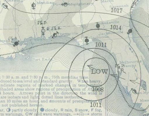
| current | 03:26, 7 December 2009 | | 510 × 396 (50 KB) | Juliancolton | {{Information |Description={{en|1=A weather map on August 12, 1939 depicting Hurricane #2 over the Gulf of Mexico near Florida.}} |Source=http://docs.lib.noaa.gov/rescue/dwm/1939/19390812.djvu |Author=[http://docs.lib.noaa.gov/rescue/dwm/data_rescue_daily |
File usage
The following pages on the English Wikipedia use this file (pages on other projects are not listed):
Global file usage
The following other wikis use this file:
- Usage on zh.wiki.x.io