
Original file (1,370 × 1,370 pixels, file size: 140 KB, MIME type: image/png)
Summary
edit
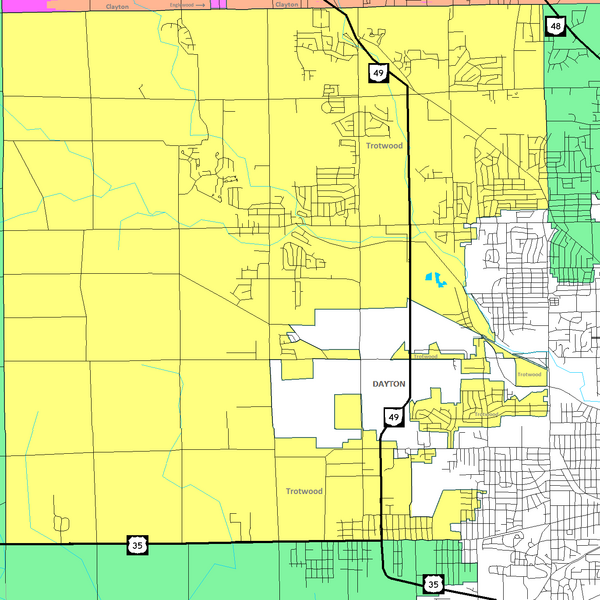
Map of Trotwood, Ohio with surrounding communities and roads Highlighting the various separated sections of the city that were created when the City of Trotwood and surrounding Madison Township (Montgomery County, Ohio) merged. There is one unattached area that completely surrounded by the City of Dayton, Ohio. Other smaller areas are connected only by a roadway or a small strip of land.
Licensing
edit
 | I, the creator of this work, hereby grant the permission to copy, distribute and/or modify this document under the terms of the GNU Free Documentation License, Version 1.2 or any later version published by the Free Software Foundation; with no Invariant Sections, no Front-Cover Texts, and no Back-Cover Texts. Subject to disclaimers. |
| This work is licensed under the Creative Commons Attribution-ShareAlike 3.0 License. This licensing tag was added to this file as part of the GFDL licensing update. |
 | This file is a candidate to be copied to Wikimedia Commons.
Any user may perform this transfer; refer to Wikipedia:Moving files to Commons for details. If this file has problems with attribution, copyright, or is otherwise ineligible for Commons, then remove this tag and DO NOT transfer it; repeat violators may be blocked from editing. Other Instructions
| ||
| |||
| This media file is either in the public domain or published under a free license, and contains no inbound file links. If this media file is useful, then it should be transferred to the Wikimedia Commons. If this media is not useful, then please propose it for deletion or list it at files for discussion. |
File history
Click on a date/time to view the file as it appeared at that time.
| Date/Time | Thumbnail | Dimensions | User | Comment | |
|---|---|---|---|---|---|
| current | 21:10, 13 August 2006 | | 1,370 × 1,370 (140 KB) | Prinzwilhelm (talk | contribs) | Map of Trotwood, Ohio with surrounding communities and roads Highlighting the various separated sections of the city that were created when the City of Trotwood and surrounding Madison Township (Montgomery County, Ohio) merged. There is one unattached are |
| 21:09, 13 August 2006 |  | 1,370 × 1,370 (140 KB) | Prinzwilhelm (talk | contribs) | Map of Trotwood, Ohio with surrounding communities and roads Highlighting the various separated sections of the city that were created when the City of Trotwood and surrounding Madison Township (Montgomery County, Ohio) merged. There is one unattached are | |
| 21:04, 13 August 2006 |  | 1,370 × 1,370 (140 KB) | Prinzwilhelm (talk | contribs) | Map of Trotwood, Ohio with surrounding communities and roads Highlighting the various separated sections of the city that were created when the City of Trotwood and surrounding Madison Township (Montgomery County, Ohio) merged. There is one unattached ar |
You cannot overwrite this file.