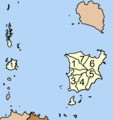
Tambon_8404.png (377 × 402 pixels, file size: 15 KB, MIME type: image/png)
File history
Click on a date/time to view the file as it appeared at that time.
| Date/Time | Thumbnail | Dimensions | User | Comment | |
|---|---|---|---|---|---|
| current | 17:09, 23 March 2006 |  | 377 × 402 (15 KB) | Ahoerstemeier | Map of Ko Samui district, Surat Thani province, with the communes (tambon) numbered #Ang Thong (อ่างทอง) #Li Pa Noi (ลิปะน้อย) #Taling Ngam (ตลิ่งงาม) #Na Mueang (หน้าเมือง) #Ma Ret (มะ� |
File usage
The following page uses this file:
Global file usage
The following other wikis use this file:
- Usage on ar.wiki.x.io
- Usage on az.wiki.x.io
- Usage on da.wiki.x.io
- Usage on de.wiki.x.io
- Usage on de.wikivoyage.org
- Usage on eu.wiki.x.io
- Usage on fi.wiki.x.io
- Usage on frr.wiki.x.io
- Usage on fr.wiki.x.io
- Usage on he.wiki.x.io
- Usage on hr.wiki.x.io
- Usage on it.wiki.x.io
- Usage on ja.wiki.x.io
- Usage on km.wiki.x.io
- Usage on lt.wiki.x.io
- Usage on my.wiki.x.io
- Usage on nl.wiki.x.io
- Usage on pa.wiki.x.io
- Usage on ru.wiki.x.io
- Usage on th.wiki.x.io
- Usage on uk.wiki.x.io
- Usage on vi.wiki.x.io
- Usage on wuu.wiki.x.io
- Usage on zh.wiki.x.io


