
Size of this preview: 800 × 598 pixels. Other resolutions: 320 × 239 pixels | 640 × 479 pixels | 979 × 732 pixels.
Original file (979 × 732 pixels, file size: 16 KB, MIME type: image/png)
| This is a file from the Wikimedia Commons. Information from its description page there is shown below. Commons is a freely licensed media file repository. You can help. |
Summary
| Description |
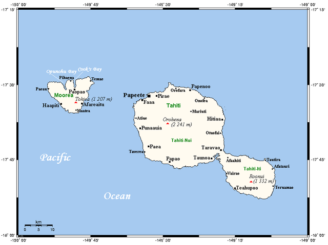
English: A map of Tahiti and Moorea in the Society Islands (French Polynesia) showing main centres and peaks |
| Date | not specified |
| Source | This map's source is here (select Papeete in the search box), with the uploader's modifications, and the GMT homepage says that the tools are released under the GNU General Public License |
| Author | Kelisi at en.wikipedia |

|
This map image could be re-created using vector graphics as an SVG file. This has several advantages; see Commons:Media for cleanup for more information. If an SVG form of this image is available, please upload it and afterwards replace this template with
{{vector version available|new image name}}.
It is recommended to name the SVG file “TahitiMooreaMap.svg”—then the template Vector version available (or Vva) does not need the new image name parameter. |
Licensing
Kelisi at the English-language Wikipedia, the copyright holder of this work, hereby publishes it under the following license:
| This file is licensed under the Creative Commons Attribution-Share Alike 3.0 Unported license. Subject to disclaimers. | ||
| Attribution: Kelisi at the English-language Wikipedia | ||
| ||
| This licensing tag was added to this file as part of the GFDL licensing update. |

|
Permission is granted to copy, distribute and/or modify this document under the terms of the GNU Free Documentation License, Version 1.2 or any later version published by the Free Software Foundation; with no Invariant Sections, no Front-Cover Texts, and no Back-Cover Texts. A copy of the license is included in the section entitled GNU Free Documentation License. Subject to disclaimers. |
Original upload log
All following user names refer to en.wikipedia.
- 2006-04-22 16:30 Kelisi 972×732×8 (16 KB) (Map of Tahiti and Moorea showing main centres, peaks. This map's source is [http://www.aquarius.geomar.de/omc/make_map.html here], with the uploader's modifications, and the [http://gmt.soest.hawaii.edu/ GMT homepage] says that the tools are released unde)
File history
Click on a date/time to view the file as it appeared at that time.
| Date/Time | Thumbnail | Dimensions | User | Comment | |
|---|---|---|---|---|---|
| current | 08:47, 11 February 2009 | | 979 × 732 (16 KB) | Telim tor | == Information == {{Information |Description={{en|A map of Tahiti and Moorea in the Society Islands, French Polynesia}} |Source=This map's source is [http://www.aquarius.ifm-geomar.de/ here], with the uploader's modifications, and the [http://gmt.soest.ha |
File usage
The following pages on the English Wikipedia use this file (pages on other projects are not listed):
Global file usage
The following other wikis use this file:
- Usage on af.wiki.x.io
- Usage on es.wiki.x.io
- Usage on fa.wiki.x.io
- Usage on fi.wiki.x.io
- Usage on fr.wiki.x.io
- Usage on gl.wiki.x.io
- Usage on hu.wiki.x.io
- Usage on id.wiki.x.io
- Usage on it.wiki.x.io
- Usage on ja.wiki.x.io
- Usage on ka.wiki.x.io
- Usage on kn.wiki.x.io
- Usage on lt.wiki.x.io
- Usage on mk.wiki.x.io
- Usage on nl.wiki.x.io
- Usage on no.wiki.x.io
- Usage on pl.wikivoyage.org
- Usage on pt.wiki.x.io
- Usage on ro.wiki.x.io
- Usage on ru.wiki.x.io
- Usage on ta.wiki.x.io
- Usage on ty.wiki.x.io
- Usage on uk.wiki.x.io
- Usage on xmf.wiki.x.io
- Usage on zh-yue.wiki.x.io
- Usage on zh.wiki.x.io