.jpg)
.jpg&action=edit&redlink=1)

Size of this preview: 759 × 600 pixels. Other resolutions: 304 × 240 pixels | 608 × 480 pixels | 972 × 768 pixels | 1,280 × 1,011 pixels | 2,560 × 2,022 pixels | 3,095 × 2,445 pixels.
Original file (3,095 × 2,445 pixels, file size: 1,002 KB, MIME type: image/jpeg)
| This is a file from the Wikimedia Commons. Information from its description page there is shown below. Commons is a freely licensed media file repository. You can help. |
.jpg)
Summary
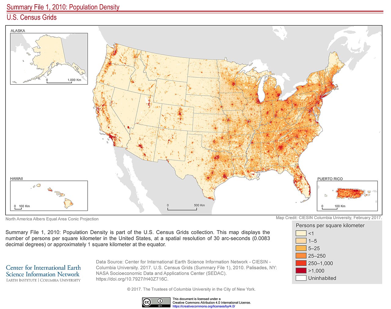
| Description | Summary File 1, 2010: Population Density is part of the U.S. Census Grids collection. This map displays the number of persons per square kilometer in the United States, at a spatial resolution of 30 arc-seconds (0.0083 decimal degrees) or approximately 1 square kilometer at the equator. See more information at <a href="https://doi.org/10.7927/H40Z716C" rel="nofollow">doi.org/10.7927/H40Z716C</a>. |
| Date | |
| Source | Summary File 1, 2010: Population Density |
| Author | SEDACMaps |
Licensing
This file is licensed under the Creative Commons Attribution 2.0 Generic license.
- You are free:
- to share – to copy, distribute and transmit the work
- to remix – to adapt the work
- Under the following conditions:
- attribution – You must give appropriate credit, provide a link to the license, and indicate if changes were made. You may do so in any reasonable manner, but not in any way that suggests the licensor endorses you or your use.
| This image was originally posted to Flickr by SEDACMaps at https://flickr.com/photos/54545503@N04/34337604624 (archive). It was reviewed on 21 December 2019 by FlickreviewR 2 and was confirmed to be licensed under the terms of the cc-by-2.0. |
File history
Click on a date/time to view the file as it appeared at that time.
| Date/Time | Thumbnail | Dimensions | User | Comment | |
|---|---|---|---|---|---|
| current | 02:04, 21 December 2019 | | 3,095 × 2,445 (1,002 KB) | Ser Amantio di Nicolao | Transferred from Flickr via #flickr2commons |
File usage
The following pages on the English Wikipedia use this file (pages on other projects are not listed):
.jpg)