Size of this preview: 696 × 599 pixels. Other resolutions: 279 × 240 pixels | 558 × 480 pixels | 992 × 854 pixels.
Original file (992 × 854 pixels, file size: 394 KB, MIME type: image/png)
File history
Click on a date/time to view the file as it appeared at that time.
| Date/Time | Thumbnail | Dimensions | User | Comment | |
|---|---|---|---|---|---|
| current | 19:31, 20 February 2006 |  | 992 × 854 (394 KB) | Ζεύς | |
| 19:26, 20 February 2006 |  | 1,253 × 854 (431 KB) | Ζεύς | ||
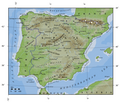
| 03:29, 10 February 2006 |  | 827 × 712 (259 KB) | Ζεύς | Topographical map of Spain including names of the most prominent geographical features. |
File usage
No pages on the English Wikipedia use this file (pages on other projects are not listed).
Global file usage
The following other wikis use this file:
- Usage on ar.wiki.x.io
- Usage on es.wikibooks.org
- Usage on ky.wiki.x.io