Size of this preview: 800 × 591 pixels. Other resolutions: 320 × 236 pixels | 640 × 473 pixels | 1,024 × 756 pixels | 1,083 × 800 pixels.
Original file (1,083 × 800 pixels, file size: 63 KB, MIME type: image/png)
File history
Click on a date/time to view the file as it appeared at that time.
| Date/Time | Thumbnail | Dimensions | User | Comment | |
|---|---|---|---|---|---|
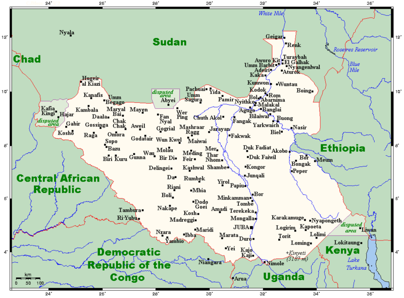
| current | 05:28, 7 September 2023 |  | 1,083 × 800 (63 KB) | Kelisi | >>>Disputed borders in purple; some changes in placenames |
| 01:14, 24 April 2012 |  | 1,083 × 800 (60 KB) | Spesh531 | removing white from sudan, waw-->wau and uwayi-->aweil | |
| 00:42, 24 April 2012 |  | 1,083 × 800 (61 KB) | Spesh531 | removing two non-significant towns in sudan | |
| 00:42, 24 April 2012 |  | 1,083 × 800 (60 KB) | Spesh531 | removing two non-significant towns in sudan | |
| 00:23, 24 April 2012 |  | 1,083 × 800 (60 KB) | Spesh531 | Added Chad in the way Saudi Arabia is in the Sudan file | |
| 00:18, 24 April 2012 |  | 1,083 × 800 (60 KB) | Spesh531 | I think this is a bit more accurate. I made so only important cities (As google maps show at a certain zoom) show in sudan, and made the border between sudan and south sudan like to other countries. | |
| 04:32, 23 April 2012 |  | 989 × 995 (84 KB) | Kelisi | {{Information |Description=Map of Cities, towns and selected villages in South Sudan. |Source=en:Image:SudanOMC.png |Date=13:01, 23 April 2012 (UTC) |Author=User:Kelisi |other_versions= }} {... |
File usage
The following 2 pages use this file:
Global file usage
The following other wikis use this file:
- Usage on cs.wiki.x.io
- Usage on es.wiki.x.io
- Usage on it.wiki.x.io
- Usage on ms.wiki.x.io
- Usage on nl.wiki.x.io
- Usage on sv.wiki.x.io
- Usage on tum.wiki.x.io
- Usage on uk.wiki.x.io
