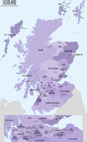
Size of this preview: 369 × 600 pixels. Other resolutions: 147 × 240 pixels | 295 × 480 pixels | 1,000 × 1,625 pixels.
Original file (1,000 × 1,625 pixels, file size: 905 KB, MIME type: image/png)
File history
Click on a date/time to view the file as it appeared at that time.
| Date/Time | Thumbnail | Dimensions | User | Comment | |
|---|---|---|---|---|---|
| current | 21:46, 27 April 2009 |  | 1,000 × 1,625 (905 KB) | XrysD | Image reduced in size and text made more larger to increase legibility |
| 21:08, 27 April 2009 |  | 2,000 × 3,250 (2.1 MB) | XrysD | {{Information |Description={{en|1=Map of the administrative divisions of Scotland}} |Source=Own work by uploader |Author=XrysD |Date=2009-04-27 |Permission= |other_versions= }} <!--{{ImageUpload|full}}--> |
File usage
The following 2 pages use this file:
Global file usage
The following other wikis use this file:
- Usage on cs.wiki.x.io
- Usage on eu.wiki.x.io
- Britainia Handia
- Edinburgo
- Glasgow
- Aberdeen
- Dundee
- Inverness
- Highland
- Shetlandak
- Orkadak
- Argyll eta Bute
- Angus
- Txantiloi:Eskoziako konderri aurkibidea
- Scottish Borders
- Aberdeenshire
- Dumfries eta Galloway
- Fife
- Iparraldeko Ayrshire
- Moray
- Clackmannanshire
- Inverclyde
- Renfrewshire
- Midlothian
- Perth eta Kinross
- Falkirk (eremu administratiboa)
- Stirling (eremu administratiboa)
- Ekialdeko Ayrshire
- Ekialdeko Dunbartonshire
- Ekialdeko Lothian
- Ekialdeko Renfrewshire
- Iparraldeko Lanarkshire
- Hegoaldeko Ayrshire
- Hegoaldeko Lanarkshire
- Mendebaldeko Dunbartonshire
- Mendebaldeko Lothian
- Eskoziako azpibanaketak
- Comhairle nan Eilean Siar
- Usage on fa.wiki.x.io
- Usage on gl.wiki.x.io
- Usage on gv.wiki.x.io
- Usage on he.wiki.x.io
- Usage on hy.wiki.x.io
- Usage on id.wiki.x.io
- Usage on is.wiki.x.io
- Usage on it.wiki.x.io
- Usage on la.wiki.x.io
- Usage on mk.wiki.x.io
- Usage on nl.wiki.x.io
- Usage on oc.wiki.x.io
View more global usage of this file.
