
Size of this PNG preview of this SVG file: 800 × 500 pixels. Other resolutions: 320 × 200 pixels | 640 × 400 pixels | 1,024 × 641 pixels | 1,280 × 801 pixels | 2,560 × 1,601 pixels | 1,020 × 638 pixels.
Original file (SVG file, nominally 1,020 × 638 pixels, file size: 1.08 MB)
| This is a file from the Wikimedia Commons. Information from its description page there is shown below. Commons is a freely licensed media file repository. You can help. |

|
Standardization of derivative maps
Feel free to create derivations of this work, but if you want to illustrate a Wikipedia article with derivative works of this or similar maps of Brazil, please strictly follow the visual standard, nomenclature and classification already in use. All maps of Brazilian subdivisions are being adaptated or created in this way. We do not want to inhibit creativity but the pattern adopted here was presented and accepted by the Lusophone community and should be followed whenever possible. |
| Description |
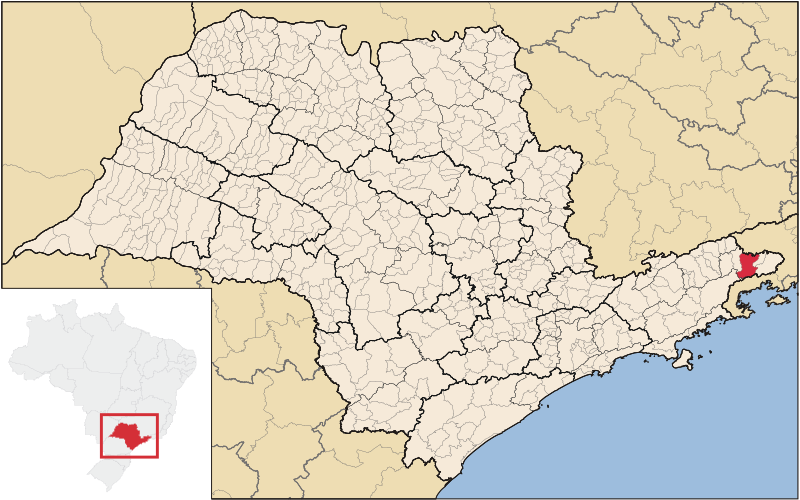
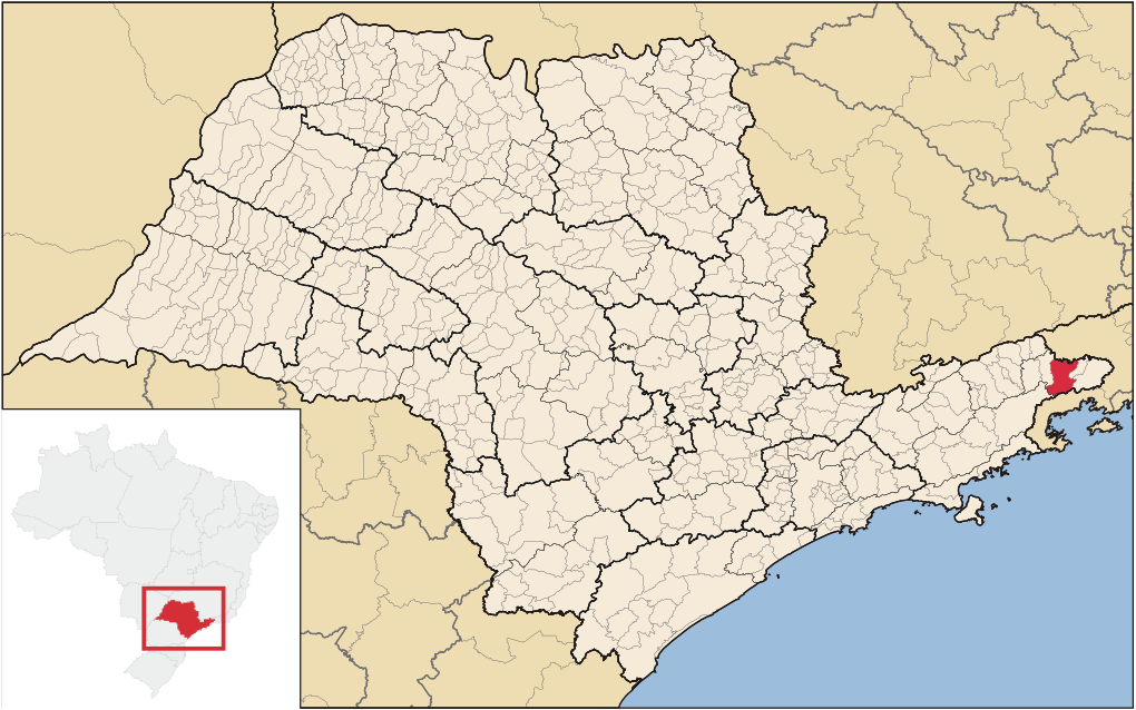
English: Map locator of São Paulo's São José do Barreiro city, Brazil.
Português: Mapa de localização do Município de São José do Barreiro no Estado de São Paulo, Brasil. |
||||||||
| Date | |||||||||
| Source | Image:SaoPaulo_MesoMicroMunicip.svg Raphael Lorenzeto de Abreu | ||||||||
| Author | own work | ||||||||
| Permission (Reusing this file) |
I, the copyright holder of this work, hereby publish it under the following licenses:
This file is licensed under the Creative Commons Attribution 2.5 Generic license.
You may select the license of your choice. |

File history
Click on a date/time to view the file as it appeared at that time.
| Date/Time | Thumbnail | Dimensions | User | Comment | |
|---|---|---|---|---|---|
| current | 21:44, 2 April 2012 | | 1,020 × 638 (1.08 MB) | Marquinhos | Standardizing with the actually version image source, carried by Raphael Lorenzeto de Abreu. |
| 13:46, 14 July 2006 |  | 1,024 × 691 (1.19 MB) | Srfortes | {{User:Raphael.lorenzeto/DerivativeMaps}} {{Information| |Description=Mapa de localização do Município de São José do Barreiro no Estado de São Paulo, Brasil. |Source=Image:SaoPaulo_MesoMicroMunicip.svg Raphael Lorenzeto de Abreu |Date=July |
File usage
The following pages on the English Wikipedia use this file (pages on other projects are not listed):
Global file usage
The following other wikis use this file:
- Usage on arz.wiki.x.io
- Usage on bpy.wiki.x.io
- Usage on eo.wiki.x.io
- Usage on es.wiki.x.io
- Usage on eu.wiki.x.io
- Usage on io.wiki.x.io
- Usage on it.wiki.x.io
- Usage on nl.wiki.x.io
- Usage on no.wiki.x.io
- Usage on pt.wiki.x.io
- Usage on ro.wiki.x.io
- Usage on tt.wiki.x.io
- Usage on vi.wiki.x.io
- Usage on www.wikidata.org
- Usage on zh-min-nan.wiki.x.io
- Usage on zh.wiki.x.io