No higher resolution available.
SPC_1630_UTC_outlook_with_watches_and_radar_3-31-2023.gif (582 × 408 pixels, file size: 154 KB, MIME type: image/gif, looped, 7 frames, 3.5 s)
| This is a file from the Wikimedia Commons. Information from its description page there is shown below. Commons is a freely licensed media file repository. You can help. |
Summary
| Description |
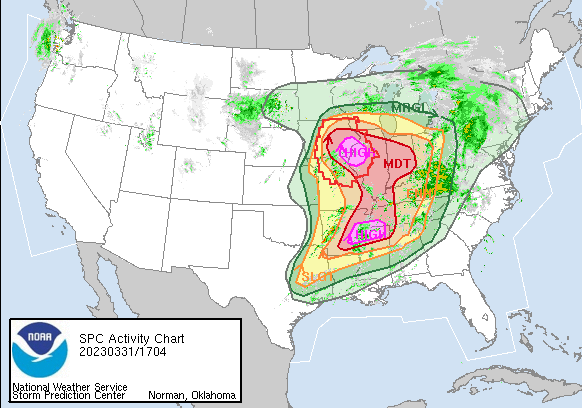
English: The SPC 1630 UTC outlook for 3/31/2023 with the watches and radar imagery overlayed.
  "...THERE IS A HIGH RISK OF SEVERE THUNDERSTORMS FOR FAR SOUTHEAST
  IOWA...WEST-CENTRAL ILLINOIS...FAR NORTHEAST MISSOURI AND IN PARTS
  OF EASTERN ARKANSAS...NORTHERN MISSISSIPPI...AND SOUTHWESTERN
  TENNESSEE...
...SUMMARY... A severe weather outbreak appears increasingly likely, centered on this afternoon and evening, across a large portion of the Mississippi Valley. At least a few long-track, strong to potentially violent tornadoes are probable, particularly over portions of the Mid-Mississippi Valley to the Mid-South. Swaths of intense damagingwind gusts along with very large hail are expected as well." |
| Date | |
| Source | https://www.spc.noaa.gov/ |
| Author | Storm Prediction Center |
Licensing
| This file is in the public domain in the United States because it was solely created by the National Weather Service (including its name from 1870–1970, the United States Weather Bureau).
As a file created by an employee of the NWS (formerly USWB) in the course of their official duties, whether hosted
this work is in the public domain in the United States because it is a work prepared by an officer or employee of the United States Government as part of that person’s official duties under the terms of Title 17, Chapter 1, Section 105 of the US Code. |
||
 |
Warnings:
|
File history
Click on a date/time to view the file as it appeared at that time.
| Date/Time | Thumbnail | Dimensions | User | Comment | |
|---|---|---|---|---|---|
| current | 03:23, 1 April 2023 | | 582 × 408 (154 KB) | ChessEric | Uploaded a work by Storm Prediction Center from https://www.spc.noaa.gov/ with UploadWizard |
File usage
The following pages on the English Wikipedia use this file (pages on other projects are not listed):