
Size of this preview: 618 × 599 pixels. Other resolutions: 247 × 240 pixels | 495 × 480 pixels.
Original file (800 × 776 pixels, file size: 358 KB, MIME type: image/png)
| This is a file from the Wikimedia Commons. Information from its description page there is shown below. Commons is a freely licensed media file repository. You can help. |
| Description |
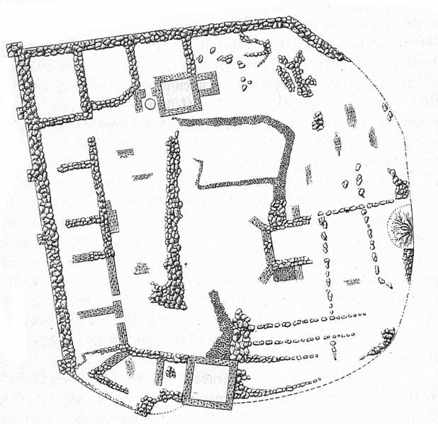
Dansk: Grundplan af ruiner af Søborg Slot. |
||||
| Date | circa 1885 | ||||
| Source | Nordens Historie af Niels Bache (bf.II-298). Forlagsbureauet i Kjøbenhavn 1885. | ||||
| Author | Unknown author | ||||
| Permission (Reusing this file) |
|
||||
| Object location | | View this and other nearby images on: OpenStreetMap |
|---|
File history
Click on a date/time to view the file as it appeared at that time.
| Date/Time | Thumbnail | Dimensions | User | Comment | |
|---|---|---|---|---|---|
| current | 15:05, 18 October 2006 | | 800 × 776 (358 KB) | Nico-dk | {{Information|Ruiner af Søborg Slot |Description='''Grundplan af ruiner af Søborg Slot'''. |Source=''Nordens Historie'' af Niels Bache (bf.II-298). Forlagsbureauet i Kjøbenhavn 1885. |Date=Around 1885 |Author=unknown |Permission= {{PD-old}} }} [[Cate |
File usage
The following pages on the English Wikipedia use this file (pages on other projects are not listed):
Global file usage
The following other wikis use this file:
- Usage on da.wiki.x.io
- Usage on de.wiki.x.io
- Usage on fr.wiki.x.io