
Size of this preview: 800 × 527 pixels. Other resolutions: 320 × 211 pixels | 640 × 422 pixels | 921 × 607 pixels.
Original file (921 × 607 pixels, file size: 141 KB, MIME type: image/jpeg)
| This is a file from the Wikimedia Commons. Information from its description page there is shown below. Commons is a freely licensed media file repository. You can help. |
Summary
| Description |
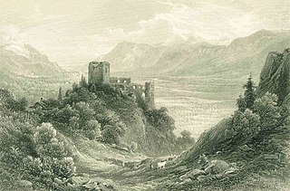
English: Mid 19th century steel engraving, Ruins of the Brunnenburg, near Meran, South Tyrol
|
||
| Date | circa 1845 | ||
| Source | Antique print | ||
| Author | After a painting by Compton | ||
| Permission (Reusing this file) |
public domain |
| Object location | | View this and other nearby images on: OpenStreetMap |
|---|
Licensing
|
This work is in the public domain in its country of origin and other countries and areas where the copyright term is the author's life plus 70 years or fewer. | |
| This file has been identified as being free of known restrictions under copyright law, including all related and neighboring rights. | |
File history
Click on a date/time to view the file as it appeared at that time.
| Date/Time | Thumbnail | Dimensions | User | Comment | |
|---|---|---|---|---|---|
| current | 09:58, 5 February 2009 | | 921 × 607 (141 KB) | Xn4 | {{Information |Description={{en|1=Mid 19th century steel engraving, ''Ruins of the Brunnenburg, near Meran, South Tyrol'' }} |Source=Antique print |Author=After a painting by Compton |Date=c. 1845 |Permission=public domain |other_versions= }} <!--{{Image |
File usage
The following pages on the English Wikipedia use this file (pages on other projects are not listed):
Global file usage
The following other wikis use this file:
- Usage on de.wiki.x.io
- Usage on nl.wiki.x.io