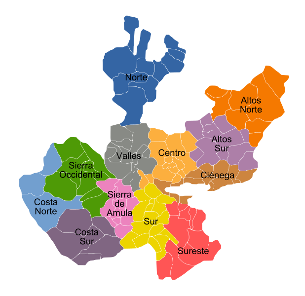
Size of this PNG preview of this SVG file: 618 × 599 pixels. Other resolutions: 247 × 240 pixels | 495 × 480 pixels | 792 × 768 pixels | 1,056 × 1,024 pixels | 2,111 × 2,048 pixels | 1,000 × 970 pixels.
Original file (SVG file, nominally 1,000 × 970 pixels, file size: 332 KB)
File history
Click on a date/time to view the file as it appeared at that time.
| Date/Time | Thumbnail | Dimensions | User | Comment | |
|---|---|---|---|---|---|
| current | 21:23, 30 April 2009 |  | 1,000 × 970 (332 KB) | Jpablo cad | Colores, tipografía, tamaño, y aspecto, mejoras en el aspecto. |
| 18:39, 6 October 2008 |  | 1,278 × 1,240 (200 KB) | Jpablo cad | {{Information |Description= |Source= |Date= |Author= |Permission= |other_versions= }} | |
| 03:06, 5 October 2008 |  | 1,278 × 1,198 (200 KB) | Jpablo cad | {{Information |Description={{es|1=Mapa de Jalisco con sus respectivas regiones administrativas.}} |Source=trabajo propio (own work) |Author=Jpablo cad |Date=2008-10-04 |Permission= |other_versions= }} <!--{{ImageUpload|full}}--> [[Cat |
File usage
The following 2 pages use this file:
Global file usage
The following other wikis use this file:
- Usage on ast.wiki.x.io
- Usage on de.wiki.x.io
- Usage on eo.wiki.x.io
- Jalisco (regionoj)
- Acatic
- Acatlán de Juárez
- Ahualulco de Mercado
- Amacueca
- Amatitán
- Ameca (komunumo)
- San Juanito Escobedo
- Arandas (Jalisco)
- El Arenal (Jalisco)
- Atemajac de Brizuela
- Atengo
- Atenguillo
- Atotonilco el Alto
- Atoyac
- Autlán de Navarro
- Ayotlán
- Ayutla
- La Barca
- Bolaños
- Cabo Corrientes
- Casimiro Castillo
- Cihuatlán
- Zapotlán El Grande
- Cocula
- Colotlán (komunumo)
- Concepción de Buenos Aires
- Cuautitlán de García Barragán
- Chapala
- Cuautla (Jalisco)
- Cuquío
- Chimaltitán
- Chiquilistlán
- Degollado
- Ejutla
- Encarnación de Díaz
- Etzatlán
- El Grullo
- Guachinango
- Guadalajara (komunumo)
- Hostotipaquillo
- Huejúcar
- Huejuquilla el Alto
- La Huerta
- Ixtlahuacán de los Membrillos
- Ixtlahuacán del Río
- Jalostotitlán
View more global usage of this file.