File:Portugueselanguagedialects-Brazil.png

Original file (885 × 915 pixels, file size: 11 KB, MIME type: image/png)

Summary

Description
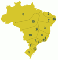
Português: Zonas dialetais do português brasileiro
Legenda: 1 - Caipira; 2 - Costa norte; 3 - Baiano; 4 - Fluminense; 5 - Gaúcho; 6 - Mineiro; 7 - Nordestino; 8 - Nortista; 9 - Paulistano; 10 - Sertanejo; 11 - Sulista; 12 - Florianopolitano; 13 - Carioca; 14 - Brasiliense; 15 - Serra amazônica; 16 - Recifense
English: Portuguese language dialects in Brazil
Date
Source

O mapa em questão foi elaborado primariamente tendo como base as obras de Antenor Nascentes, com enriquecimentos bibliográficos em: Amadeu Amaral (O Dialeto Caipira, 1920), Mário Marroquim (A Língua do Nordeste, 1945) e Serafim Neto (Introdução ao estudo da língua portuguesa no Brasil, 1950). O esboço inicial do mapa teve como base a proposição de Nascentes, como pode ser observada aqui: [1]. Só que como observa a própria UFPE, no projeto "Zonas Dialetais Brasileiras", o que existe como mapa dialetal, está simplificado e "envelhecido", pois não abarcou importantes zonas como o sulista, caipira e o gaúcho. Desde então vários estudos tem tentado identificar as novas variantes e proposto sua localização de influencia geográfica dentro do território brasileiro.

As referencias para reorganizar o mapa vieram principalmente dos estudos já conduzidos pela UFBA (projeto ALiB), UFPE (projeto "Zonas Dialetais Brasileiras"), a UFPA (Língua e Literatura Vernácula no Brasil), FCCM (Projeto de resgate histórico e cultural do Sul do Pará "Rondon-Carajás") e UNASP (projeto "Fala Brasil").

Outras fontes importantes:

Author PedroPVZ
File:Portugueselanguagedialects-Brazil (colored).svg is a vector version of this file. It should be used in place of this PNG file when not inferior.

File:Portugueselanguagedialects-Brazil.png → File:Portugueselanguagedialects-Brazil (colored).svg

For more information, see Help:SVG.

In other languages
Alemannisch  العربية  беларуская (тарашкевіца)  български  বাংলা  català  нохчийн  čeština  dansk  Deutsch  Ελληνικά  English  British English  Esperanto  español  eesti  euskara  فارسی  suomi  français  Frysk  galego  Alemannisch  עברית  hrvatski  magyar  հայերեն  Bahasa Indonesia  Ido  italiano  日本語  ქართული  한국어  lietuvių  македонски  മലയാളം  Bahasa Melayu  norsk bokmål  Plattdüütsch  Nederlands  norsk nynorsk  norsk  occitan  polski  português  português do Brasil  română  русский  sicilianu  Scots  slovenčina  slovenščina  српски / srpski  svenska  தமிழ்  ไทย  Türkçe  татарча / tatarça  українська  vèneto  Tiếng Việt  中文  中文(中国大陆)  中文(简体)  中文(繁體)  中文(马来西亚)  中文(新加坡)  中文(臺灣)  +/−
New SVG image


From en: Wikipedia

Uploaded (del) (cur) 18:47, 8 August 2004 . . PedroPVZ (Talk) . . 885x915 (22243 bytes) (Made by user:PedroPVZ from wikipedia's Maps)

Annotations
InfoField
This image is annotated: View the annotations at Commons

Licensing

w:en:Creative Commons
attribution share alike
This file is licensed under the Creative Commons Attribution-Share Alike 3.0 Unported license. Subject to disclaimers.
You are free:
  • to share – to copy, distribute and transmit the work
  • to remix – to adapt the work
Under the following conditions:
  • attribution – You must give appropriate credit, provide a link to the license, and indicate if changes were made. You may do so in any reasonable manner, but not in any way that suggests the licensor endorses you or your use.
  • share alike – If you remix, transform, or build upon the material, you must distribute your contributions under the same or compatible license as the original.
This licensing tag was added to this file as part of the GFDL licensing update.
GNU head Permission is granted to copy, distribute and/or modify this document under the terms of the GNU Free Documentation License, Version 1.2 or any later version published by the Free Software Foundation; with no Invariant Sections, no Front-Cover Texts, and no Back-Cover Texts. A copy of the license is included in the section entitled GNU Free Documentation License. Subject to disclaimers.

Captions

Add a one-line explanation of what this file represents

Items portrayed in this file

depicts

8 August 2004

File history

Click on a date/time to view the file as it appeared at that time.

(newest | oldest) View (newer 10 | ) (10 | 20 | 50 | 100 | 250 | 500)
Date/TimeThumbnailDimensionsUserComment
current23:42, 23 July 2016Thumbnail for version as of 23:42, 23 July 2016885 × 915 (11 KB)LuizdlAjuste nas linhas do sul de Minas e do cone leste paulista. Tamanho de arquivo menor.
00:38, 20 September 2014Thumbnail for version as of 00:38, 20 September 2014885 × 915 (32 KB)Hallelleve ajuste nas linhas
19:00, 18 July 2013Thumbnail for version as of 19:00, 18 July 2013885 × 915 (45 KB)HallelCorreção em linhas do dialeto 15
21:03, 17 July 2013Thumbnail for version as of 21:03, 17 July 2013885 × 915 (31 KB)HallelDelineando limites entre as regiões dialetais
15:54, 16 July 2013Thumbnail for version as of 15:54, 16 July 2013885 × 915 (26 KB)HallelAjuste em numeração
02:13, 16 July 2013Thumbnail for version as of 02:13, 16 July 2013885 × 915 (26 KB)Hallel+dialeto recifense
02:54, 24 September 2012Thumbnail for version as of 02:54, 24 September 2012885 × 915 (10 KB)Capmosame as before but borderless
02:46, 24 September 2012Thumbnail for version as of 02:46, 24 September 2012885 × 915 (25 KB)Capmoadditional dialects but keeping original numbering
02:07, 24 September 2012Thumbnail for version as of 02:07, 24 September 2012885 × 915 (22 KB)CapmoReverted to version as of 17:11, 31 January 2006 - no problem in adding new dialects, but please don't change the original numbering
00:48, 24 September 2012Thumbnail for version as of 00:48, 24 September 2012885 × 915 (44 KB)HallelAcréscimo dos dialetos Brasiliense, Florianopolitano, Fluminense e Amazônida da Serra; Correção da numeração, colocando-a em correta ordem alfabética.
(newest | oldest) View (newer 10 | ) (10 | 20 | 50 | 100 | 250 | 500)

The following page uses this file:

Global file usage

Metadata