File:Poinsett Bridge, SC Route 42, 2 miles Northwest of Route 11, 2.5 miles East of SC Route 25, Tigerville vicinity (Greenville County, South Carolina).jpg

Size of this preview: 424 × 600 pixels. Other resolutions: 170 × 240 pixels | 339 × 480 pixels | 543 × 768 pixels | 724 × 1,024 pixels | 1,448 × 2,048 pixels | 3,251 × 4,597 pixels.
Original file (3,251 × 4,597 pixels, file size: 2.15 MB, MIME type: image/jpeg)
| This is a file from the Wikimedia Commons. Information from its description page there is shown below. Commons is a freely licensed media file repository. You can help. |
Summary
| Description |
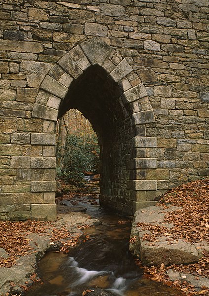
English: Poinsett Bridge, SC Route 42, 2 miles Northwest of Route 11, 2.5 miles East of SC Route 25, Tigerville vicinity (Greenville County, South Carolina). |
|||||||||||||||||||||||||
| Date | ||||||||||||||||||||||||||
| Source |
Historic American Engineering Record, Libray of Congress, Call number: HAER SC,23-TIGVI.V,1-20
|
|||||||||||||||||||||||||
| Author |
|
|||||||||||||||||||||||||

.jpg)
.jpg&action=edit&redlink=1)
.jpg)
Licensing
| This image or media file contains material based on a work of a National Park Service employee, created as part of that person's official duties. As a work of the U.S. federal government, such work is in the public domain in the United States. See the NPS website and NPS copyright policy for more information. |
|
File history
Click on a date/time to view the file as it appeared at that time.
| Date/Time | Thumbnail | Dimensions | User | Comment | |
|---|---|---|---|---|---|
| current | 02:06, 17 March 2009 | | 3,251 × 4,597 (2.15 MB) | Martin H. | High res; cropped |
| 20:53, 15 June 2008 |  | 417 × 594 (119 KB) | KudzuVine | {{Information |Description={{en|1=Poinsett Bridge, SC Route 42, 2 miles Northwest of Route 11, 2.5 miles East of SC Route 25, Tigerville vicinity (Greenville County, South Carolina) {{HAER}}}} |Source=Poinsett Bridge, SC Route 42, 2 miles Northwest of Rou |
File usage
The following pages on the English Wikipedia use this file (pages on other projects are not listed):
.jpg)