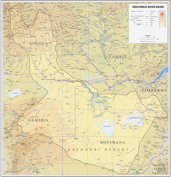
Size of this preview: 579 × 599 pixels. Other resolutions: 232 × 240 pixels | 464 × 480 pixels | 742 × 768 pixels | 989 × 1,024 pixels | 1,978 × 2,048 pixels | 3,052 × 3,160 pixels.
Original file (3,052 × 3,160 pixels, file size: 8.63 MB, MIME type: image/png)
File history
Click on a date/time to view the file as it appeared at that time.
| Date/Time | Thumbnail | Dimensions | User | Comment | |
|---|---|---|---|---|---|
| current | 14:22, 6 January 2019 |  | 3,052 × 3,160 (8.63 MB) | JMK | adjust midtones |
| 17:09, 16 April 2008 |  | 3,052 × 3,160 (8.15 MB) | Foundert~commonswiki | {{Information |Description=map of the Okavango River Basin (Angola, Namibia, Botswana) |Source=http://www.un.org/Depts/Cartographic/english/htmain.htm |Date=16. April 2008 |Author=United Nations |Permission=UN map as PD |other_versions= }} {{UN map}} [[ |
File usage
The following 4 pages use this file:
Global file usage
The following other wikis use this file:
- Usage on af.wiki.x.io
- Usage on ar.wiki.x.io
- Usage on ast.wiki.x.io
- Usage on avk.wiki.x.io
- Usage on azb.wiki.x.io
- Usage on bg.wiki.x.io
- Usage on ca.wiki.x.io
- Usage on cs.wiki.x.io
- Usage on da.wiki.x.io
- Usage on de.wiki.x.io
- Usage on el.wiki.x.io
- Usage on es.wiki.x.io
- Usage on fi.wiki.x.io
- Usage on frr.wiki.x.io
- Usage on fr.wiki.x.io
- Usage on he.wiki.x.io
- Usage on hr.wiki.x.io
- Usage on hu.wiki.x.io
- Usage on id.wiki.x.io
- Usage on it.wiki.x.io
- Usage on ja.wiki.x.io
- Usage on ka.wiki.x.io
- Usage on ko.wiki.x.io
- Usage on lt.wiki.x.io
- Usage on lv.wiki.x.io
- Usage on mk.wiki.x.io
- Usage on ml.wiki.x.io
- Usage on nl.wiki.x.io
- Usage on oc.wiki.x.io
- Usage on pl.wiki.x.io
- Usage on pt.wiki.x.io
- Usage on ro.wiki.x.io
- Usage on sh.wiki.x.io
- Usage on sk.wiki.x.io
- Usage on sr.wiki.x.io
- Usage on sw.wiki.x.io
- Usage on ta.wiki.x.io
- Usage on th.wiki.x.io
- Usage on uk.wiki.x.io
View more global usage of this file.

