
Size of this PNG preview of this SVG file: 494 × 600 pixels. Other resolutions: 198 × 240 pixels | 395 × 480 pixels | 633 × 768 pixels | 843 × 1,024 pixels | 1,687 × 2,048 pixels | 1,108 × 1,345 pixels.
Original file (SVG file, nominally 1,108 × 1,345 pixels, file size: 302 KB)
| This is a file from the Wikimedia Commons. Information from its description page there is shown below. Commons is a freely licensed media file repository. You can help. |
Summary
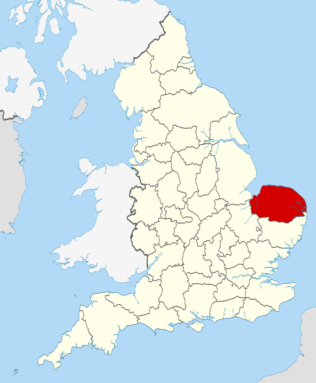
| Description | Location of the ceremonial county of Norfolk within England. |
| Date | |
| Source |
National Geospatial-Intelligence Agency
|
| Author | Nilfanion |
Licensing
I, the copyright holder of this work, hereby publish it under the following licenses:
This file is licensed under the Creative Commons Attribution-Share Alike 3.0 Unported license.
- You are free:
- to share – to copy, distribute and transmit the work
- to remix – to adapt the work
- Under the following conditions:
- attribution – You must give appropriate credit, provide a link to the license, and indicate if changes were made. You may do so in any reasonable manner, but not in any way that suggests the licensor endorses you or your use.
- share alike – If you remix, transform, or build upon the material, you must distribute your contributions under the same or compatible license as the original.

|
Permission is granted to copy, distribute and/or modify this document under the terms of the GNU Free Documentation License, Version 1.2 or any later version published by the Free Software Foundation; with no Invariant Sections, no Front-Cover Texts, and no Back-Cover Texts. A copy of the license is included in the section entitled GNU Free Documentation License. |
You may select the license of your choice.

|
This is one of the images forming part of the Valued image set: Locator maps of the Ceremonial counties of England on Wikimedia Commons. The image set has been assessed under the valued image set criteria and is considered the most valued set on Commons within the scope:
Locator maps of the Ceremonial counties of England
You can see its nomination at Commons:Valued image candidates/Locator maps of English ceremonial counties. |
File history
Click on a date/time to view the file as it appeared at that time.
| Date/Time | Thumbnail | Dimensions | User | Comment | |
|---|---|---|---|---|---|
| current | 22:40, 23 November 2010 | | 1,108 × 1,345 (302 KB) | Nilfanion | == Summary == {{Information |Description=Location of the ceremonial county of Norfolk within England. |Source=Ordnance Survey [https://www.ordnancesurvey.co.uk/opendatadownload/products.html OpenData]: *County boundarie |
File usage
More than 100 pages use this file. The following list shows the first 100 pages that use this file only. A full list is available.
- Alby with Thwaite
- Aldborough, Norfolk
- Aldeby
- Alderford
- Alpington
- Anmer
- Arminghall
- Ashmanhaugh
- Aslacton
- Attlebridge
- Bacton, Norfolk
- Bagthorpe with Barmer
- Barford, Norfolk
- Barnham Broom
- Barsham, Norfolk
- Bawsey
- Beacon Hill, Colkirk, Norfolk
- Bedingham
- Beeston, Norfolk
- Beeston St Andrew
- Beeston with Bittering
- Besthorpe, Norfolk
- Billingford, Breckland
- Bintree
- Bircham
- Bircham Newton
- Bixley
- Booton, Norfolk
- Boughton, Norfolk
- Bracon Ash
- Bradenham, Norfolk
- Bradwell, Norfolk
- Brockdish
- Brooke, Norfolk
- Bure Valley Path
- Burgh and Tuttington
- Carleton Rode
- Cess, Norfolk
- Crome's Broad
- Crown Point, Norwich
- Halvergate
- Horningtoft
- Hoveton Great Broad
- Ingoldisthorpe
- Irstead
- Kirstead Green
- Lothingland
- Ludham Bridge
- Malthouse Broad
- Mid-Yare National Nature Reserve
- Morston
- Neatishead
- Norfolk
- Norfolk Burnhams
- North Creake
- Oxwick
- Pattesley
- Poringland
- Pulham Market
- Quidenham
- Ranworth
- Reedham, Norfolk
- Ringland, Norfolk
- River Chet
- Salhouse Broad
- Sandringham, Norfolk
- Saxlingham Nethergate
- Scottow
- Scoulton
- Sculthorpe, Norfolk
- Shelfanger
- Shereford
- South Creake
- South Walsham
- Spooner Row
- St Olaves
- Stow Bedon
- Sturston, Norfolk
- Swardeston
- Testerton
- Titchwell
- Toftrees
- Trunch
- Upton, Norfolk
- Upton Fen
- Wayford Bridge
- Weavers' Way
- West Dereham
- Westwick, Norfolk
- Winterton Dunes
- Wood Dalling
- Wood Norton, Norfolk
- Woodton
- Wormegay
- Wortwell
- Wramplingham
- Wreningham
- Wretham
- Wretton
- Wroxham Broad
View more links to this file.
Global file usage
The following other wikis use this file:
- Usage on af.wiki.x.io
- Usage on ar.wiki.x.io
- Usage on ast.wiki.x.io
- Usage on az.wiki.x.io
- Usage on be-tarask.wiki.x.io
- Usage on bg.wiki.x.io
- Usage on br.wiki.x.io
- Usage on ca.wiki.x.io
- Usage on ceb.wiki.x.io
- Usage on ckb.wiki.x.io
- Usage on cs.wiki.x.io
- Usage on da.wiki.x.io
- Usage on en.wikinews.org
- Usage on eo.wiki.x.io
- Usage on es.wiki.x.io
- Usage on eu.wiki.x.io
- Usage on fa.wiki.x.io
- Usage on fi.wiki.x.io
- Usage on fr.wiktionary.org
- Usage on ga.wiki.x.io
- Usage on gl.wiki.x.io
- Usage on he.wiki.x.io
- Usage on hu.wiki.x.io
- Usage on ia.wiki.x.io
- Usage on ja.wiki.x.io
- Usage on ko.wiki.x.io
- Usage on la.wiki.x.io
- Usage on lld.wiki.x.io
- Usage on lt.wiki.x.io
- Usage on lv.wiki.x.io
- Usage on nl.wiki.x.io
- Usage on oc.wiki.x.io
- Usage on os.wiki.x.io
- Usage on pl.wiki.x.io
- Usage on pl.wikivoyage.org
- Usage on pl.wiktionary.org
- Usage on pnb.wiki.x.io
- Usage on pt.wiki.x.io
- Usage on sh.wiki.x.io
View more global usage of this file.