Size of this preview: 556 × 600 pixels. Other resolutions: 222 × 240 pixels | 445 × 480 pixels | 927 × 1,000 pixels.
Original file (927 × 1,000 pixels, file size: 967 KB, MIME type: image/png)
File history
Click on a date/time to view the file as it appeared at that time.
| Date/Time | Thumbnail | Dimensions | User | Comment | |
|---|---|---|---|---|---|
| current | 10:39, 15 August 2009 |  | 927 × 1,000 (967 KB) | Lencer | Reverted to version as of 09:28, 11 December 2008, please upload a seperate version! |
| 09:49, 15 August 2009 |  | 927 × 1,000 (1,010 KB) | רוליג | מ | |
| 09:28, 11 December 2008 |  | 927 × 1,000 (967 KB) | Lencer | {{Information |Description= |Source= |Date= |Author= |Permission= |other_versions= }} | |
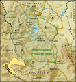
| 19:17, 3 December 2008 |  | 928 × 1,000 (1.01 MB) | Lencer | {{Information| |Description=Karte des Nationalparks Plitvicer Seen in Kroatien |Source=own work, used: * Generic Mapping Tools and SRTM3 V2-files for relief * Minimap made |
File usage
The following 2 pages use this file:
Global file usage
The following other wikis use this file:
- Usage on ban.wiki.x.io
- Usage on cs.wiki.x.io
- Usage on de.wiki.x.io
- Usage on fr.wiki.x.io
- Usage on he.wiki.x.io
- Usage on hr.wiki.x.io
- Usage on hu.wiki.x.io
- Usage on ko.wiki.x.io
- Usage on mt.wiki.x.io
- Usage on my.wiki.x.io
- Usage on simple.wiki.x.io
- Usage on sq.wiki.x.io
- Usage on te.wiki.x.io
- Usage on vi.wiki.x.io
- Usage on www.wikidata.org

