No higher resolution available.
National-atlas-missouri.png (771 × 584 pixels, file size: 119 KB, MIME type: image/png)
| This is a file from the Wikimedia Commons. Information from its description page there is shown below. Commons is a freely licensed media file repository. You can help. |
Summary
Transwiki approved by: w:en:User:Dmcdevit
This image was copied from wikipedia:en. The original description was:
Licensing
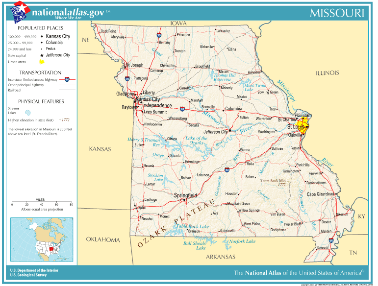
This map was obtained from an edition of the National Atlas of the United States. Like almost all works of the U.S. federal government, works from the National Atlas are in the public domain in the United States.
Online access: NationalAtlas.gov | 1970 print edition: Library of Congress, Perry-Castañeda Library
|
Original upload log
| date/time | username | resolution | size | edit summary |
|---|---|---|---|---|
| 11:49, 12 December 2004 | w:en:User:Berkut | 771×584 | 119 KB | reduced file size |
| 00:46, 1 December 2004 | w:en:User:Jengod | 771×584 | 341 KB | {{PD-USGov-Atlas}} |
Image description page history
| link | date/time | username | edit summary |
|---|---|---|---|
| http://en.wiki.x.io/w/index.php?title=Image:National-atlas-missouri.png&redirect=no&oldid=16977019 | 07:14, 10 September 2007 | w:en:User:Dmcdevit | |
| http://en.wiki.x.io/w/index.php?title=Image:National-atlas-missouri.png&redirect=no&oldid=16977019 | 00:46, 1 December 2004 | w:en:User:Jengod | |
| http://en.wiki.x.io/w/index.php?title=Image:National-atlas-missouri.png&redirect=no&oldid=8000703 | 00:46, 1 December 2004 | w:en:User:Jengod | ({{PD-USGov-Atlas}} ) |
File history
Click on a date/time to view the file as it appeared at that time.
| Date/Time | Thumbnail | Dimensions | User | Comment | |
|---|---|---|---|---|---|
| current | 16:12, 10 September 2007 | | 771 × 584 (119 KB) | BetacommandBot | Transwiki approved by: w:en:User:Dmcdevit This image was copied from wikipedia:en. The original description was: {{PD-USGov-Atlas}} w:en:Category:Missouri maps === File history === {| class=wikitable ! date/time || username || resolution || s |
File usage
The following pages on the English Wikipedia use this file (pages on other projects are not listed):
Global file usage
The following other wikis use this file:
- Usage on bs.wiki.x.io
- Usage on fa.wiki.x.io
- Usage on gu.wiki.x.io
- Usage on hi.wiki.x.io
- Usage on io.wiki.x.io
- Usage on it.wiki.x.io
- Usage on ja.wiki.x.io
- Usage on kk.wiki.x.io
- Usage on kn.wiki.x.io
- Usage on lt.wiki.x.io
- Usage on nl.wiki.x.io
- Usage on no.wiki.x.io
- Usage on ro.wiki.x.io
- Usage on tr.wiki.x.io
- Usage on vi.wiki.x.io