
Size of this preview: 450 × 600 pixels. Other resolutions: 180 × 240 pixels | 360 × 480 pixels | 576 × 768 pixels | 768 × 1,024 pixels | 1,536 × 2,048 pixels.
Original file (1,536 × 2,048 pixels, file size: 1.86 MB, MIME type: image/jpeg)
| This is a file from the Wikimedia Commons. Information from its description page there is shown below. Commons is a freely licensed media file repository. You can help. |
Summary
| Description |
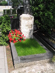
Polski: Grób Konstantego Ildefonsa Gałczyńskiego |
| Date | |
| Source | Own work |
| Author | GrzegorzPetka |
| OpenStreetMap | Node 1942622279 |
| Object location | | View this and other nearby images on: OpenStreetMap |
|---|
Licensing
| I, the copyright holder of this work, release this work into the public domain. This applies worldwide. In some countries this may not be legally possible; if so: I grant anyone the right to use this work for any purpose, without any conditions, unless such conditions are required by law. |
File history
Click on a date/time to view the file as it appeared at that time.
| Date/Time | Thumbnail | Dimensions | User | Comment | |
|---|---|---|---|---|---|
| current | 15:27, 22 July 2008 | | 1,536 × 2,048 (1.86 MB) | GrzegorzPetka | {{Information |Description={{pl|1=Grób Konstantego Ildefonsa Gałczyńskiego}} |Source=Praca własna osoby przesyłającej (own work by uploader) |Author=GrzegorzPetka |Date=22.07.2008 |Permission= |other_versions= }} {{ImageUploa |
File usage
The following page uses this file:
Global file usage
The following other wikis use this file:
- Usage on cs.wiki.x.io
- Usage on it.wiki.x.io
- Usage on pl.wiki.x.io
- Usage on ru.wiki.x.io
- Usage on uk.wiki.x.io
- Usage on vi.wiki.x.io
- Usage on www.wikidata.org