No higher resolution available.
Mizoramdistrictsmap.png (379 × 600 pixels, file size: 14 KB, MIME type: image/png)
| This is a file from the Wikimedia Commons. Information from its description page there is shown below. Commons is a freely licensed media file repository. You can help. |
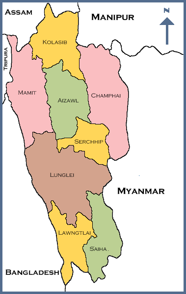
| Description | A map of Mizoram state displaying its 8 districts | ||
| Source | http://en.wiki.x.io/wiki/File:Mizoramdistricts1.png | ||
| Author | User:Joy1963 | ||
| Permission (Reusing this file) |
English Wikipedia user User:Joy1963, the copyright holder of this work, hereby publishes it under the following license:
|

File history
Click on a date/time to view the file as it appeared at that time.
| Date/Time | Thumbnail | Dimensions | User | Comment | |
|---|---|---|---|---|---|
| current | 05:58, 19 April 2010 | | 379 × 600 (14 KB) | Tianyamm2 | {{Information |Description=A map of Mizoram state displaying its 8 districts |Source=http://en.wiki.x.io/wiki/File:Mizoramdistricts1.png |Date= |Author=User:Joy1963 |Permission={{GFDL-user-w|en|English Wikipedia|User:Joy1963}} |other_versions= }} |
File usage
The following page uses this file:
Global file usage
The following other wikis use this file:
- Usage on as.wiki.x.io
- Usage on bn.wiki.x.io
- Usage on eo.wiki.x.io
- Usage on es.wiki.x.io
- Usage on fr.wiki.x.io
- Usage on gu.wiki.x.io
- Usage on ha.wiki.x.io
- Usage on hif.wiki.x.io
- Usage on hr.wiki.x.io
- Usage on id.wiki.x.io
- Usage on my.wiki.x.io
- Usage on nl.wiki.x.io
- Usage on no.wiki.x.io
- Usage on or.wiki.x.io
- Usage on pa.wiki.x.io
- Usage on pnb.wiki.x.io
- Usage on pt.wiki.x.io
- Usage on sa.wiki.x.io
- Usage on ta.wiki.x.io
- Usage on ta.wiktionary.org
- Usage on www.wikidata.org
- Usage on zh-min-nan.wiki.x.io
- Usage on zh.wiki.x.io