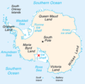
Map-antarctica-ross-ice-shelf-red-x.png (316 × 313 pixels, file size: 26 KB, MIME type: image/png)
File history
Click on a date/time to view the file as it appeared at that time.
| Date/Time | Thumbnail | Dimensions | User | Comment | |
|---|---|---|---|---|---|
| current | 17:22, 16 February 2009 |  | 316 × 313 (26 KB) | Jeandré du Toit | {{Information |Description=*Map of Antarctica with a red X on the Ross ice shelf. |Source=*File:Antarctica_Map.png |Date=2009-02-16 17:20 (UTC) |Author=*File:Antarctica_Map.png *derivative work: ~~~ |Permission=see below |other_versions= }} { |
File usage
The following page uses this file:
Global file usage
The following other wikis use this file:
- Usage on fi.wiki.x.io
- Usage on gv.wiki.x.io
- Usage on id.wiki.x.io
- Usage on ja.wiki.x.io
- Usage on mk.wiki.x.io
- Usage on ms.wiki.x.io
- Usage on pt.wiki.x.io
- Usage on zh.wiki.x.io

