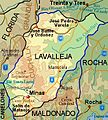
Lavalleja_Department_map.jpg (315 × 351 pixels, file size: 126 KB, MIME type: image/jpeg)
File history
Click on a date/time to view the file as it appeared at that time.
| Date/Time | Thumbnail | Dimensions | User | Comment | |
|---|---|---|---|---|---|
| current | 15:21, 23 September 2012 |  | 315 × 351 (126 KB) | Hoverfish | Correct name of capital |
| 11:58, 23 September 2012 |  | 315 × 351 (131 KB) | Hoverfish | Reupload | |
| 11:55, 23 September 2012 |  | 315 × 351 (131 KB) | Hoverfish | Added roadsigns | |
| 23:04, 22 September 2012 |  | 315 × 351 (130 KB) | Hoverfish | {{Information |Description ={{en|1=Map of Lavalleja Department, Uruguay. }} |Source ={{own}} |Author =Hoverfish |Date =2012-09-22 |Permission = |other_versions = }} [[Category:Lavalleja Department| ]... |
File usage
The following page uses this file:
Global file usage
The following other wikis use this file:
- Usage on ar.wiki.x.io
- Usage on ka.wiki.x.io
- Usage on no.wiki.x.io
- Usage on ru.wiki.x.io
- Usage on sk.wiki.x.io
- Usage on www.wikidata.org
