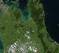
Kopuatai_peat_dome.jpg (552 × 501 pixels, file size: 38 KB, MIME type: image/jpeg)
File history
Click on a date/time to view the file as it appeared at that time.
| Date/Time | Thumbnail | Dimensions | User | Comment | |
|---|---|---|---|---|---|
| current | 21:25, 8 January 2011 |  | 552 × 501 (38 KB) | Dramatic | {{Information |Description={{en|1=Section of North Island of New Zealand centred on the Hauraki Plains. Auckland is at the top left, Tauranga bottom right. The Kopuatai peat dome is the footprint-shaped brown area centre.}} |Source=http://earthobservatory |
File usage
The following page uses this file:
Global file usage
The following other wikis use this file:
- Usage on es.wiki.x.io
- Usage on www.wikidata.org


