Size of this PNG preview of this SVG file: 800 × 401 pixels. Other resolutions: 320 × 160 pixels | 640 × 321 pixels | 1,024 × 513 pixels | 1,280 × 642 pixels | 2,560 × 1,283 pixels | 848 × 425 pixels.
Original file (SVG file, nominally 848 × 425 pixels, file size: 4.98 MB)
File history
Click on a date/time to view the file as it appeared at that time.
| Date/Time | Thumbnail | Dimensions | User | Comment | |
|---|---|---|---|---|---|
| current | 13:26, 7 September 2011 |  | 848 × 425 (4.98 MB) | Bourrichon | +Parcs nationaux |
| 13:23, 7 September 2011 |  | 848 × 425 (4.98 MB) | Bourrichon | +Parcs nationaux | |
| 13:20, 6 September 2011 |  | 848 × 425 (4.95 MB) | Bourrichon | Carte de localisation svg | |
| 13:08, 6 September 2011 |  | 848 × 425 (4.85 MB) | Bourrichon | recadrage | |
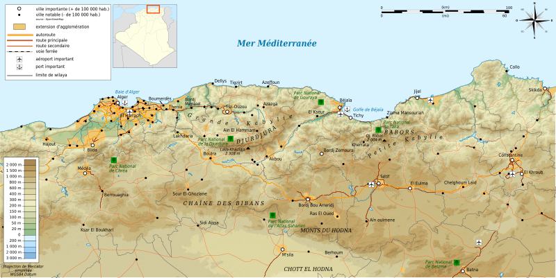
| 12:59, 6 September 2011 |  | 1,052 × 744 (5.03 MB) | Bourrichon | == {{int:filedesc}} == {{Location|36|30|00|N|03|30|00|E|scale:500000}} {{Information |Description= {{fr|Carte topographique en français de la fr:Kabylie}} {{de|Topographische Karte zum de:Kabylei, in Französische}} {{en|Topographic map in |
File usage
The following 5 pages use this file:
Global file usage
The following other wikis use this file:
- Usage on als.wiki.x.io
- Usage on ar.wiki.x.io
- Usage on cs.wiki.x.io
- Usage on de.wiki.x.io
- Usage on de.wikiversity.org
- Usage on el.wiki.x.io
- Usage on es.wiki.x.io
- Usage on fa.wiki.x.io
- Usage on fi.wiki.x.io
- Usage on fr.wiki.x.io
- Usage on gl.wiki.x.io
- Usage on is.wiki.x.io
- Usage on it.wiki.x.io
- Usage on ja.wiki.x.io
- Usage on ro.wiki.x.io
- Usage on scn.wiki.x.io
- Usage on sv.wiki.x.io
- Usage on uk.wiki.x.io
- Usage on www.wikidata.org


