No higher resolution available.
Jever_Ostfriesland_1500.png (800 × 600 pixels, file size: 1.13 MB, MIME type: image/png)
| This is a file from the Wikimedia Commons. Information from its description page there is shown below. Commons is a freely licensed media file repository. You can help. |
| Description |
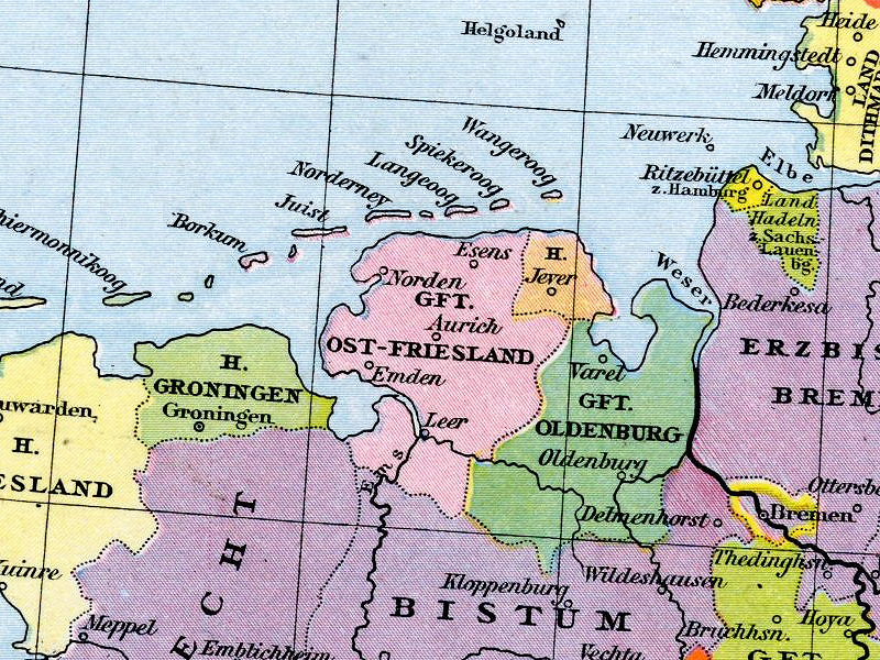
Deutsch: Herrschaft Jever in Friesland um 1500
English: Herrschaft Jever and Grafschaft Ostfriesland and surrounding territories about 1500 |
| Date | circa 1500 Klasing 1886 Ostfriesland 1500 |
| Source | Johann Gustav Droysen, Allgemeiner Historischer Handatlas in 96 Karten mit erläuterndem Text, Velhagen & Klasing 1886, S. 34. Digitalized version |
| Author |
|
This work is in the public domain in its country of origin and other countries and areas where the copyright term is the author's life plus 70 years or fewer. | |
| This file has been identified as being free of known restrictions under copyright law, including all related and neighboring rights. | |
File history
Click on a date/time to view the file as it appeared at that time.
| Date/Time | Thumbnail | Dimensions | User | Comment | |
|---|---|---|---|---|---|
| current | 12:50, 29 June 2008 | | 800 × 600 (1.13 MB) | Simplicius | |
| 14:46, 9 October 2005 |  | 331 × 240 (151 KB) | Alexander Fischer | ''Herrschaft Jever'' and ''Grafschaft Ostfriesland'' and surrounding territories about 1500 *Source: Johann Gustav Droysen, ''Allgemeiner historischer Handatlas in 96 Karten mit erläuterndem Text'', Velhagen & Klasing 1886. |
File usage
The following 2 pages use this file:
Global file usage
The following other wikis use this file:
- Usage on azb.wiki.x.io
- Usage on bg.wiki.x.io
- Usage on de.wiki.x.io
- Usage on et.wiki.x.io
- Usage on fa.wiki.x.io
- Usage on frr.wiki.x.io
- Usage on fr.wiki.x.io
- Usage on fy.wiki.x.io
- Usage on hu.wiki.x.io
- Usage on ja.wiki.x.io
- Usage on mk.wiki.x.io
- Usage on pl.wiki.x.io
- Usage on pt.wiki.x.io
- Usage on ru.wiki.x.io
- Usage on uk.wiki.x.io