
Size of this PNG preview of this SVG file: 231 × 231 pixels. Other resolutions: 240 × 240 pixels | 480 × 480 pixels | 768 × 768 pixels | 1,024 × 1,024 pixels | 2,048 × 2,048 pixels.
Original file (SVG file, nominally 231 × 231 pixels, file size: 37 KB)
| This is a file from the Wikimedia Commons. Information from its description page there is shown below. Commons is a freely licensed media file repository. You can help. |
Summary
| Description |
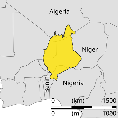
English: Sketch map illustrating location of the Iullemmeden basin in West Africa |
| Date | |
| Source | Own work |
| Author | Aymatth2 |
Licensing
| I, the copyright holder of this work, release this work into the public domain. This applies worldwide. In some countries this may not be legally possible; if so: I grant anyone the right to use this work for any purpose, without any conditions, unless such conditions are required by law. |
File history
Click on a date/time to view the file as it appeared at that time.
| Date/Time | Thumbnail | Dimensions | User | Comment | |
|---|---|---|---|---|---|
| current | 08:18, 26 June 2011 | | 231 × 231 (37 KB) | Ciaurlec | Changed colours to uniform to others geological maps |
| 18:22, 7 February 2011 |  | 231 × 231 (38 KB) | Ciaurlec | Moved objects to differents layers | |
| 19:18, 18 December 2010 |  | 231 × 231 (18 KB) | Aymatth2 | {{Information |Description={{en|1=Sketch map illustrating location of the Iullemmeden basin in West Africa}} |Source={{own}} |Author=Aymatth2 |Date=2010-12-18 |Permission= |other_versions= }} Category:Geology of Africa |
File usage
The following page uses this file:
Global file usage
The following other wikis use this file:
- Usage on de.wiki.x.io
- Usage on es.wiki.x.io
- Usage on it.wiki.x.io
- Usage on nl.wiki.x.io