
Size of this preview: 361 × 599 pixels. Other resolutions: 144 × 240 pixels | 289 × 480 pixels | 876 × 1,454 pixels.
Original file (876 × 1,454 pixels, file size: 490 KB, MIME type: image/jpeg)
| This is a file from the Wikimedia Commons. Information from its description page there is shown below. Commons is a freely licensed media file repository. You can help. |
Summary
| Description |
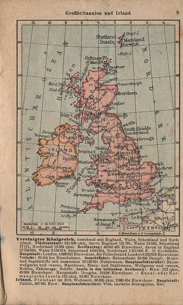
Polski: Mapa Wielkiej Brytanii i Irlandii z niemieckiego atlasu kieszonkowego, 1939/1940 English: Map of Great Britain and Ireland from german pocket atlas, 1939/1940 |
| Date | |
| Source | Private collection |
| Author | Unknown author |
Licensing
|
This work is in the public domain in its country of origin and other countries and areas where the copyright term is the author's life plus 70 years or fewer. | |
| This file has been identified as being free of known restrictions under copyright law, including all related and neighboring rights. | |
File history
Click on a date/time to view the file as it appeared at that time.
| Date/Time | Thumbnail | Dimensions | User | Comment | |
|---|---|---|---|---|---|
| current | 11:40, 5 January 2015 | | 876 × 1,454 (490 KB) | Hoa binh | User created page with UploadWizard |
File usage
The following pages on the English Wikipedia use this file (pages on other projects are not listed):