
Size of this preview: 372 × 598 pixels. Other resolutions: 149 × 240 pixels | 298 × 480 pixels | 477 × 768 pixels | 636 × 1,024 pixels | 1,523 × 2,450 pixels.
Original file (1,523 × 2,450 pixels, file size: 112 KB, MIME type: image/png)
| This is a file from the Wikimedia Commons. Information from its description page there is shown below. Commons is a freely licensed media file repository. You can help. |
| Description |
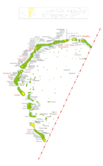
SummaryMap of w:Gaafu_Dhaalu_Atoll Map originally vector'ed by Hassan Waheed, Aabaadhuge of Thinadhoo island. Note: This section of map was extracted and its text was romanized by Oblivious. Special assitance by Waddey and Zuru Converted to PNG by helix84 |
| Date | |
| Source | Image:Gaafu_Dhaalu_Atoll.jpg |
| Author | helix84 |
| Permission (Reusing this file) |
GFDL content from English Wikipedia |
| This file is licensed under the Creative Commons Attribution-Share Alike 3.0 Unported license. Subject to disclaimers. | ||
| ||
| This licensing tag was added to this file as part of the GFDL licensing update. |

|
Permission is granted to copy, distribute and/or modify this document under the terms of the GNU Free Documentation License, Version 1.2 or any later version published by the Free Software Foundation; with no Invariant Sections, no Front-Cover Texts, and no Back-Cover Texts. A copy of the license is included in the section entitled GNU Free Documentation License. Subject to disclaimers. |
File history
Click on a date/time to view the file as it appeared at that time.
| Date/Time | Thumbnail | Dimensions | User | Comment | |
|---|---|---|---|---|---|
| current | 12:30, 14 April 2014 | | 1,523 × 2,450 (112 KB) | Rotatebot | Bot: Image rotated by 90° |
| 23:05, 28 October 2006 |  | 2,450 × 1,523 (123 KB) | Helix84 | {{Information |Description=== Summary == Map of w:Gaafu_Dhaalu_Atoll Map originally vector'ed by Hassan Waheed, Aabaadhuge of Thinadhoo island. '''''Note:''' This section of map was extracted and its text was romanized by [[:en:User:Oblivious|Oblivi |
File usage
The following pages on the English Wikipedia use this file (pages on other projects are not listed):
Global file usage
The following other wikis use this file:
- Usage on ceb.wiki.x.io
- Usage on cs.wiki.x.io
- Usage on de.wiki.x.io
- Usage on dv.wiki.x.io
- Usage on es.wiki.x.io
- Usage on fa.wiki.x.io
- Usage on fr.wiki.x.io
- Usage on id.wiki.x.io
- Usage on it.wiki.x.io
- Usage on ko.wiki.x.io
- Usage on nl.wiki.x.io
- Usage on pl.wiki.x.io
- Usage on ru.wiki.x.io
- Usage on sk.wiki.x.io
- Usage on www.wikidata.org
- Usage on zh.wiki.x.io