
Size of this preview: 800 × 515 pixels. Other resolutions: 320 × 206 pixels | 640 × 412 pixels | 1,024 × 660 pixels | 1,280 × 824 pixels | 2,560 × 1,649 pixels | 4,574 × 2,946 pixels.
Original file (4,574 × 2,946 pixels, file size: 4.31 MB, MIME type: image/jpeg)
| This is a file from the Wikimedia Commons. Information from its description page there is shown below. Commons is a freely licensed media file repository. You can help. |
Summary
| Title |
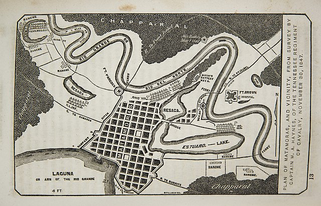
English: Plan of Matamoras, and vicinity, from survey by captain M.A. Haynes, of the Tennessee regiment of cavalry, November 30, 1847. |
||||||||||||||||||||||||||
| Description |
English: The plan depicts the city in November 1846 during the U.S. occupation. The camp of Furber's unit, the First Regiment of Tennessee Volunteers, may be seen along the river in the northwest (upper left) portion of the map. He also shows the camps of U.S. regulars as well as Illinois, Ohio, and Indiana regiments. Furber acknowledged a survey by Tennessee Mounted Volunteer Regiment Captain Milton A. Haynes (1814-1867), a West Point graduate, as the base for the map. Furber's accompanying narrative (pp. 188-241) includes an excellent description of the city, its fortifications, its inhabitants, and the vicinity around it in addition to details of camp life. |
||||||||||||||||||||||||||
| Date | between 1847 and 1848 | ||||||||||||||||||||||||||
| Source | UTA Libraries A Continent Divided | ||||||||||||||||||||||||||
| Creator |
George C. Furber Milton Andrew Haynes Stillman |
||||||||||||||||||||||||||
| Credit line |
English: The University of Texas at Arlington Libraries Special Collections |
||||||||||||||||||||||||||
| Geotemporal data | |||||||||||||||||||||||||||
| Map location | Matamoros | ||||||||||||||||||||||||||
| Georeferencing | If inappropriate please set warp_status = skip to hide. | ||||||||||||||||||||||||||
| Bibliographic data | |||||||||||||||||||||||||||
| Publication |
The twelve months volunteer; or, Journal of a private, in the Tennessee regiment of cavalry, in the campaign, in Mexico, 1846-7 |
||||||||||||||||||||||||||
| Author |
George C. Furber |
||||||||||||||||||||||||||
| Place of publication | Cincinnati | ||||||||||||||||||||||||||
| Publisher |
J.A. & U.P. James |
||||||||||||||||||||||||||
| Archival data | |||||||||||||||||||||||||||
| Collection |
|
||||||||||||||||||||||||||
Licensing

|
This file was provided to Wikimedia Commons by the University of Texas at Arlington Libraries as part of a cooperation project. The University of Texas at Arlington Libraries is part of the University of Texas at Arlington, a public research university located in Arlington, Texas.
|
This work is in the public domain in the United States because it was published (or registered with the U.S. Copyright Office) before January 1, 1929.
Public domain works must be out of copyright in both the United States and in the source country of the work in order to be hosted on the Commons. If the work is not a U.S. work, the file must have an additional copyright tag indicating the copyright status in the source country.
Note: This tag should not be used for sound recordings. |
File history
Click on a date/time to view the file as it appeared at that time.
| Date/Time | Thumbnail | Dimensions | User | Comment | |
|---|---|---|---|---|---|
| current | 17:25, 9 July 2021 | | 4,574 × 2,946 (4.31 MB) | Michael Barera | == {{int:filedesc}} == {{Map |title = {{en|'''''Plan of Matamoras, and vicinity, from survey by captain M.A. Haynes, of the Tennessee regiment of cavalry, November 30, 1847.'''''}} |description = {{en|The plan depicts the city in November 1846 during the U.S. occupation. The camp of Furber's unit, the First Regiment of Tennessee Volunteers, may be seen along the river in the northwest (upper left) portion of the map. He also shows the camps of U.S. regulars as well as Illi... |
File usage
The following pages on the English Wikipedia use this file (pages on other projects are not listed):