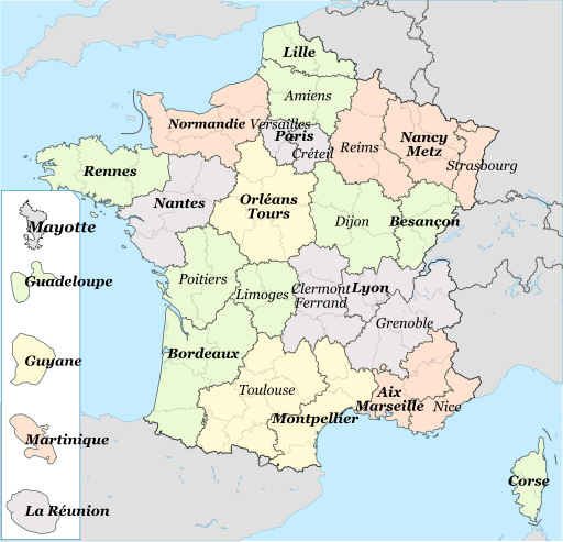
Size of this PNG preview of this SVG file: 512 × 492 pixels. Other resolutions: 250 × 240 pixels | 500 × 480 pixels | 799 × 768 pixels | 1,066 × 1,024 pixels | 2,131 × 2,048 pixels.
Original file (SVG file, nominally 512 × 492 pixels, file size: 768 KB)
File history
Click on a date/time to view the file as it appeared at that time.
| Date/Time | Thumbnail | Dimensions | User | Comment | |
|---|---|---|---|---|---|
| current | 18:27, 15 December 2021 |  | 512 × 492 (768 KB) | Ternoc | Ajout de Mayotte |
| 05:40, 8 November 2021 |  | 512 × 492 (760 KB) | Ternoc | Correction mineure | |
| 05:38, 8 November 2021 |  | 512 × 499 (759 KB) | Ternoc | Académie de Normandie | |
| 14:19, 13 December 2015 |  | 2,000 × 1,922 (1.11 MB) | Superbenjamin | Régions et circonscriptions académiques (1er janvier 2016) | |
| 23:18, 7 April 2013 |  | 553 × 584 (479 KB) | Mquinson | * Rename Ajacio to Corse (as it should) * Add several DOM académies (following the approximate geographical scale, to the best of my abilities in inkscape) - Guyane - La réunion - Guadeloupe - Martinique - Mayotte (this one is a "rectorat" ... | |
| 19:59, 4 March 2010 |  | 588 × 550 (235 KB) | Ash Crow | Removed map background... | |
| 19:58, 4 March 2010 |  | 588 × 550 (244 KB) | Ash Crow | Removed map background | |
| 19:46, 3 March 2010 |  | 588 × 550 (253 KB) | Ash Crow | {{Information |Description=== {{en|1=A map of the french academies (Mainland only)}} {{fr|1=Les académies de France métropolitaine}} |Source=*File:Enseignement_en_France_1.PNG *File:Régions_de_France.svg |Date=2010-03-03 19:42 (UTC) |Author |
File usage
The following page uses this file:
Global file usage
The following other wikis use this file:
- Usage on fr.wiki.x.io
- Académie (éducation en France)
- Académie de Bordeaux (éducation)
- Académie de Paris
- Académie d'Orléans-Tours
- Académie de Rennes
- Académie de Strasbourg
- Académie d'Amiens (éducation)
- Académie de La Réunion
- Utilisateur:LucasD/Mes images
- Académie de Poitiers
- Académie de Montpellier (éducation)
- Académie de Corse
- Académie d'Aix-Marseille
- Académie de Rouen (éducation)
- Académie de Nantes
- Académie de Toulouse
- Académie de Besançon
- Académie de Caen (éducation)
- Académie de Clermont-Ferrand
- Académie de Dijon (éducation)
- Académie de Grenoble
- Académie de Créteil
- Académie de Lyon (éducation)
- Académie de Lille
- Académie de Versailles (éducation)
- Académie de la Guadeloupe
- Académie de Nancy-Metz
- Académie de Nice
- Académie de Limoges
- Académie de Reims
- Académie de Martinique
- Académie de Guyane
- Modèle:Palette Académies françaises
- Académie des Antilles et de la Guyane
- Numéro d'identification éducation nationale
- Académie de Bourges
- Utilisatrice:Ternoc
- Lycée Robert-Schuman (homonymie)
- Utilisateur:LucasD/Brouillon/Images à trier
- Académie de Mayotte
- Académie de Normandie
- Usage on hy.wiki.x.io
- Usage on ru.wiki.x.io
- Usage on zh.wiki.x.io