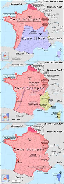
Size of this preview: 210 × 600 pixels. Other resolutions: 84 × 240 pixels | 168 × 480 pixels | 268 × 768 pixels | 358 × 1,024 pixels | 2,000 × 5,714 pixels.
Original file (2,000 × 5,714 pixels, file size: 4.26 MB, MIME type: image/jpeg)
File history
Click on a date/time to view the file as it appeared at that time.
| Date/Time | Thumbnail | Dimensions | User | Comment | |
|---|---|---|---|---|---|
| current | 11:34, 21 July 2024 | 2,000 × 5,714 (4.26 MB) | Spiridon Ion Cepleanu | Again: southern border of Oise county, restricted area on the northern frontier | |
| 11:47, 19 July 2024 | 2,000 × 5,714 (2.67 MB) | Spiridon Ion Cepleanu | Better version | ||
| 10:08, 13 July 2024 | 632 × 1,801 (893 KB) | Maisrimer | Pourquoi vouloir remettre Marseille au mauvais emplacement ??? | ||
| 08:52, 9 December 2023 | 632 × 1,801 (281 KB) | Magyar Andreasz | Reverted to version as of 13:52, 6 May 2016 (UTC) reverting the edit by MAXHO a sockpuppet who has been blocked | ||
| 11:15, 14 July 2017 | 632 × 1,801 (893 KB) | MAXHO | Marseille à la bonne place - Right place of Marseilles | ||
| 13:52, 6 May 2016 | 632 × 1,801 (281 KB) | Julieta39 | Zone d'occupation italienne dans les Alpes et Allemands à Bastia | ||
| 17:38, 8 January 2011 | 632 × 1,801 (284 KB) | Spiridon Ion Cepleanu | {{Information |Description={{en|1=France during German occupation (1940-1944)}} {{fr|1=La France durant l'Occupation}} |Source={{own}} |Author=Spiridon MANOLIU |Date=Jan. 9, 2011 |Permission= |other_versions= }} [[Category:Maps |
File usage
The following 3 pages use this file:
Global file usage
The following other wikis use this file:
- Usage on ar.wiki.x.io
- Usage on ast.wiki.x.io
- Usage on bg.wiki.x.io
- Usage on bn.wiki.x.io
- Usage on ca.wiki.x.io
- Usage on cs.wiki.x.io
- Usage on de.wiki.x.io
- Usage on es.wiki.x.io
- Usage on eu.wiki.x.io
- Usage on fa.wiki.x.io
- Usage on fr.wiki.x.io
- Usage on he.wiki.x.io
- Usage on it.wiki.x.io
- Usage on ja.wiki.x.io
- Usage on lv.wiki.x.io
- Usage on ms.wiki.x.io
- Usage on no.wiki.x.io
- Usage on pt.wiki.x.io
- Usage on ro.wiki.x.io
- Usage on sl.wiki.x.io
- Usage on www.wikidata.org
- Usage on zh.wiki.x.io


