
Size of this preview: 800 × 485 pixels. Other resolutions: 320 × 194 pixels | 640 × 388 pixels | 1,024 × 621 pixels | 1,280 × 776 pixels | 2,745 × 1,665 pixels.
Original file (2,745 × 1,665 pixels, file size: 1.4 MB, MIME type: image/png)
| This is a file from the Wikimedia Commons. Information from its description page there is shown below. Commons is a freely licensed media file repository. You can help. |
Summary
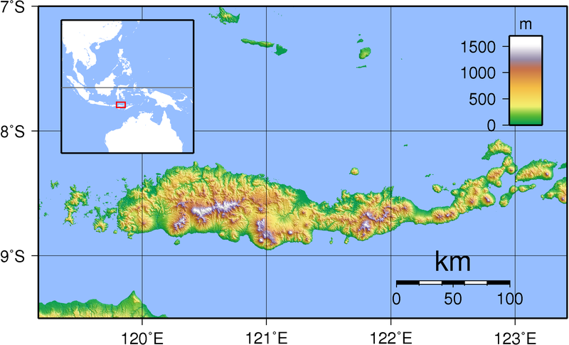
| Description | Topographic map of Flores, Indonesia. Created with GMT from SRTM data. |
| Date | |
| Source | Own work |
| Author | Sadalmelik |
Licensing
I, the copyright holder of this work, hereby publish it under the following licenses:

|
Permission is granted to copy, distribute and/or modify this document under the terms of the GNU Free Documentation License, Version 1.2 or any later version published by the Free Software Foundation; with no Invariant Sections, no Front-Cover Texts, and no Back-Cover Texts. A copy of the license is included in the section entitled GNU Free Documentation License. |
This file is licensed under the Creative Commons Attribution-Share Alike 3.0 Unported, 2.5 Generic, 2.0 Generic and 1.0 Generic license.
- You are free:
- to share – to copy, distribute and transmit the work
- to remix – to adapt the work
- Under the following conditions:
- attribution – You must give appropriate credit, provide a link to the license, and indicate if changes were made. You may do so in any reasonable manner, but not in any way that suggests the licensor endorses you or your use.
- share alike – If you remix, transform, or build upon the material, you must distribute your contributions under the same or compatible license as the original.
You may select the license of your choice.
File history
Click on a date/time to view the file as it appeared at that time.
| Date/Time | Thumbnail | Dimensions | User | Comment | |
|---|---|---|---|---|---|
| current | 21:28, 11 September 2007 | | 2,745 × 1,665 (1.4 MB) | Sadalmelik | {{Information |Description=Topographic map of Flores, Indonesia. Created with GMT from SRTM data. |Source=self-made |Date=Sep 11, 2007 |Author= Sadalmelik }} Category:Maps of Indonesia Category:Topographic maps of Asia |
File usage
The following 5 pages use this file:
Global file usage
The following other wikis use this file:
- Usage on af.wiki.x.io
- Usage on be.wiki.x.io
- Usage on bg.wiki.x.io
- Usage on da.wiki.x.io
- Usage on de.wiki.x.io
- Usage on el.wiki.x.io
- Usage on eo.wiki.x.io
- Usage on es.wiki.x.io
- Usage on fa.wiki.x.io
- Usage on frr.wiki.x.io
- Usage on fr.wiki.x.io
- Usage on gl.wiki.x.io
- Usage on he.wiki.x.io
- Usage on hr.wiki.x.io
- Usage on hu.wiki.x.io
- Usage on id.wiki.x.io
- Usage on ilo.wiki.x.io
- Usage on it.wiki.x.io
- Usage on ja.wiki.x.io
- Usage on jv.wiki.x.io
- Usage on kaa.wiki.x.io
- Usage on ka.wiki.x.io
- Usage on kk.wiki.x.io
- Usage on ko.wiki.x.io
- Usage on lv.wiki.x.io
- Usage on min.wiki.x.io
- Usage on ml.wiki.x.io
- Usage on mn.wiki.x.io
- Usage on ms.wiki.x.io
- Usage on nl.wiki.x.io
- Usage on nn.wiki.x.io
- Usage on no.wiki.x.io
- Usage on pl.wiki.x.io
- Usage on ru.wiki.x.io
- Usage on simple.wiki.x.io
- Usage on sk.wiki.x.io
- Usage on stq.wiki.x.io
View more global usage of this file.